Pljevlja geodata
Pljevlja is a seat of a first-order administrative division; located in Montenegro in Europe/Podgorica (GMT+2) time zone. With population of 19,489 people, there are 3 cities with bigger population in this country. Compared to other cities in Montenegro, 98.4% of cities are located further ↓South; 82.5% of cities are located further ←West and 76.2% of cities have lower elevation than Pljevlja. Note1


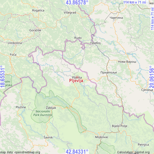
Pljevlja GPS coordinates[2]
43° 21' 24.12" North, 19° 21' 30.348" East
| Map corner | latitude | longitude |
|---|---|---|
| Upper-left | 43.86578°, | 18.65531° |
| Center: | 43.3567°, | 19.35843° |
| Lower-right: | 42.84331°, | 20.06156° |
| Map W x H: | 113.7×113.7 km | = 70.6×70.6mi |
| max Lat: | 43.38472° ⇑1.6% North |
| Pljevlja: | 43.3567° |
| min Lat: | ⇓98.4% South 41.92936° |
| min Long | Pljevlja | max Long |
| 18.50647° | 19.35843° | 20.16652° |
| W 82.5%⇐ | ⇒17.5% E |
Elevation
Elevation of Pljevlja is 772 m = 2533 ft, and this is 426 m = 1398 ft above average elevation for this country.
| Max E: |
1448 m = 4751 ft | 23.8% |
| Pljevlja | 772 m 2533 ft | |
| Avg. | 346 m = 1135 ft | |
Min E: |
4 m = 13 ft | 76.2% |
See also: Montenegro elevation on elevation.city.
Geographical zone
Pljevlja is located in North temperate zone (between Tropic of Cancer and the Arctic Circle). Distance of this Northern Tropic circle is 2214.9 km =1376.3 mi to South.| Distance of | km | miles | from Pljevlja |
|---|---|---|---|
| North Pole | 5186.2 | 3222.6 | to North |
| Arctic Circle | 2580.4 | 1603.4 | to North |
| Tropic Cancer | 2214.9 | 1376.3 | to South |
| Equator | 4820.8 | 2995.5 | to South |


Nearby cities:
15 places around Pljevlja: (largest is in red/bold)
• Barice
31.6 km =19.6 mi,  161°
161°
• Berane
70.8 km =44 mi,  143°
143°
• Bijelo Polje
47.4 km =29.5 mi, 138°
• Dučice
73.8 km =45.9 mi,  194°
194°
• Kolašin
60.8 km =37.8 mi,  167°
167°
• Kuta
71.2 km =44.2 mi,  195°
195°
• Miločani
69.3 km =43.1 mi,  212°
212°
• Mojkovac
47.7 km =29.6 mi, 157°
• Nikšić
73.1 km =45.4 mi, 207°
• Petnjica
70 km =43.5 mi, 135°
• Plužine
47.8 km =29.7 mi,  241°
241°
• Zagrad
70.9 km =44.1 mi, 197°
• Šavnik
49.3 km =30.6 mi, 205°
• Šula
23.3 km =14.5 mi,  277°
277°
• Žabljak
29.5 km =18.3 mi,  220°
220°
Sources, notices
• [Note1] Compared only with cities in Montenegro existing in our database
• [Src1] Map data: © OpenStreetMap contributors (CC-BY-SA)
• [Src2] Other city data from geonames.org with taken over terms of usage.
• [Src3] Geographical zone / Annual Mean Temperature by Robert A. Rohde @ Wikipedia
