Plužine geodata
Plužine (Opština Plužine) is a seat of a first-order administrative division; located in Montenegro in Europe/Podgorica (GMT+2) time zone. With population of 1,494 people, there are 27 cities with bigger population in this country. Compared to other cities in Montenegro, 95.2% of cities are located further ↓South; 73% of cities are located further →East and 73% of cities have lower elevation than Plužine. Note1


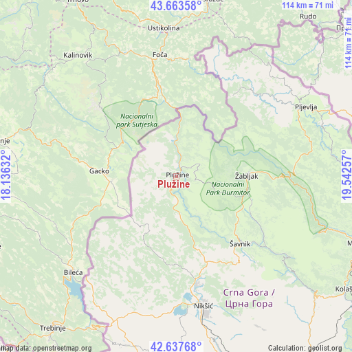
Plužine GPS coordinates[2]
43° 9' 10.008" North, 18° 50' 21.984" East
| Map corner | latitude | longitude |
|---|---|---|
| Upper-left | 43.66358°, | 18.13632° |
| Center: | 43.15278°, | 18.83944° |
| Lower-right: | 42.63768°, | 19.54257° |
| Map W x H: | 114.1×114.1 km | = 70.9×70.9mi |
| max Lat: | 43.38472° ⇑4.8% North |
| Plužine: | 43.15278° |
| min Lat: | ⇓95.2% South 41.92936° |
| min Long | Plužine | max Long |
| 18.50647° | 18.83944° | 20.16652° |
| W 27%⇐ | ⇒73% E |
Elevation
Elevation of Plužine is 693 m = 2274 ft, and this is 347 m = 1138 ft above average elevation for this country.
| Max E: |
1448 m = 4751 ft | 27% |
| Plužine | 693 m 2274 ft | |
| Avg. | 346 m = 1135 ft | |
Min E: |
4 m = 13 ft | 73% |
See also: Montenegro elevation on elevation.city.
Geographical zone
Plužine is located in North temperate zone (between Tropic of Cancer and the Arctic Circle). Distance of this Northern Tropic circle is 2192.2 km =1362.2 mi to South.| Distance of | km | miles | from Plužine |
|---|---|---|---|
| North Pole | 5208.9 | 3236.7 | to North |
| Arctic Circle | 2603 | 1617.4 | to North |
| Tropic Cancer | 2192.2 | 1362.2 | to South |
| Equator | 4798.1 | 2981.4 | to South |


Nearby cities:
15 places around Plužine: (largest is in red/bold)
• Barice
52.9 km =32.9 mi,  97°
97°
• Danilovgrad
71.1 km =44.2 mi,  159°
159°
• Dučice
53.9 km =33.5 mi,  154°
154°
• Kolašin
66.2 km =41.1 mi,  123°
123°
• Kuta
51.1 km =31.8 mi, 153°
• Miločani
36.4 km =22.6 mi,  171°
171°
• Mojkovac
64.1 km =39.8 mi,  109°
109°
• Nikšić
43.1 km =26.8 mi, 168°
• Pljevlja
47.8 km =29.7 mi,  61°
61°
• Risan
71.9 km =44.7 mi,  189°
189°
• Zagrad
49.2 km =30.6 mi, 155°
• Ćurilac
72.4 km =45 mi, 161°
• Šavnik
30.2 km =18.8 mi,  136°
136°
• Šula
32 km =19.9 mi,  36°
36°
• Žabljak
23 km =14.3 mi,  89°
89°
Sources, notices
• [Note1] Compared only with cities in Montenegro existing in our database
• [Src1] Map data: © OpenStreetMap contributors (CC-BY-SA)
• [Src2] Other city data from geonames.org with taken over terms of usage.
• [Src3] Geographical zone / Annual Mean Temperature by Robert A. Rohde @ Wikipedia
