Soanierana Ivongo geodata
Soanierana Ivongo (Analanjirofo) is a populated place; located in Madagascar in Indian/Antananarivo (GMT+3) time zone. With population of 39,271 people, there are 16 cities with bigger population in this country. Compared to other cities in Madagascar, 79.7% of cities are located further ↓South; 92.7% of cities are located further ←West and 61% of cities have higher elevation than Soanierana Ivongo. Note1
Administrative division(s):
- Level 1: Analanjirofo
- Level 2: Soanierana Ivongo
- Level 3: Soanierana Ivongo
- Level 4: Ambinany


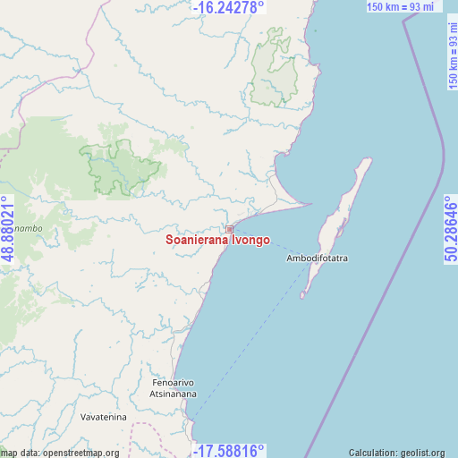
Soanierana Ivongo GPS coordinates[2]
16° 55' 0.012" South, 49° 34' 59.988" East
| Map corner | latitude | longitude |
|---|---|---|
| Upper-left | -16.24278°, | 48.88021° |
| Center: | -16.91667°, | 49.58333° |
| Lower-right: | -17.58816°, | 50.28646° |
| Map W x H: | 149.6×149.6 km | = 93×93mi |
| max Lat: | -12.31732° ⇑20.3% North |
| Soanierana Ivongo: | -16.91667° |
| min Lat: | ⇓79.7% South -25.3° |
| min Long | Soanierana Ivon | max Long |
| 43.65° | 49.58333° | 50.27876° |
| W 92.7%⇐ | ⇒7.3% E |
Elevation
Elevation of Soanierana Ivongo is 117 m = 384 ft, and this is 440.4 m = 1445 ft below average elevation for this country.
| Max E: |
1763 m = 5784 ft | 61% |
| Avg. | 557.4 m = 1829 ft | |
| Soanierana Ivongo | 117 m = 384 ft | |
Min E: |
1 m = 3 ft | 39% |
See also: Madagascar elevation on elevation.city.
Geographical zone
Soanierana Ivongo is located in South Torrid zone (between Equator and Tropic of Capricorn). Distance of this Southern Tropic circle is 725 km =450.5 mi to South.| Distance of | km | miles | from Soanierana Ivongo |
|---|---|---|---|
| Equator | 1881 | 1168.8 | to North |
| Tropic Capricorn | 725 | 450.5 | to South |
| Antarctic Circle | 5520.2 | 3430.1 | to South |
| South Pole | 8126.1 | 5049.3 | to South |


Nearby cities:
15 places around Soanierana Ivongo: (largest is in red/bold)
• Ambatondrazaka
160.4 km =99.7 mi,  230°
230°
• Ambodifotatra
29.3 km =18.2 mi,  104°
104°
• Amparafaravola
162.5 km =101 mi,  242°
242°
• Andilamena
107.9 km =67 mi,  264°
264°
• Antsirabe Afovoany
126 km =78.3 mi,  328°
328°
• Bemaitso
116.4 km =72.3 mi, 261°
• Fenoarivo Atsinanana
54.9 km =34.1 mi,  199°
199°
• Mahavelona
85.8 km =53.3 mi,  185°
185°
• Mananara
85.4 km =53.1 mi,  13°
13°
• Mandritsara
142.7 km =88.7 mi, 325°
• Maroantsetra
165.5 km =102.8 mi, 5°
• Sahatavy
85.8 km =53.3 mi, 226°
• Toamasina
138.4 km =86 mi, 187°
• Vavatenina
73.5 km =45.7 mi,  213°
213°
• Vohibinany
75.7 km =47 mi, 230°
Sources, notices
• [Note1] Compared only with cities in Madagascar existing in our database
• [Src1] Map data: © OpenStreetMap contributors (CC-BY-SA)
• [Src2] Other city data from geonames.org with taken over terms of usage.
• [Src3] Geographical zone / Annual Mean Temperature by Robert A. Rohde @ Wikipedia
