Sahatavy geodata
Sahatavy (Analanjirofo) is a populated place; located in Madagascar in Indian/Antananarivo (GMT+3) time zone. With population of 10,000 people, there are 91 cities with bigger population in this country. Compared to other cities in Madagascar, 73.2% of cities are located further ↓South; 83.7% of cities are located further ←West and 54.5% of cities have higher elevation than Sahatavy. Note1
Administrative division(s):
- Level 1: Analanjirofo
- Level 2: Vavatenina District
- Level 3: Sahatavy
- Level 4: Mahatsinjo


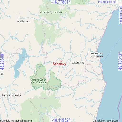
Sahatavy GPS coordinates[2]
17° 27' 0" South, 49° 0' 0" East
| Map corner | latitude | longitude |
|---|---|---|
| Upper-left | -16.77801°, | 48.29688° |
| Center: | -17.45°, | 49° |
| Lower-right: | -18.11952°, | 49.70313° |
| Map W x H: | 149.2×149.2 km | = 92.7×92.7mi |
| max Lat: | -12.31732° ⇑26.8% North |
| Sahatavy: | -17.45° |
| min Lat: | ⇓73.2% South -25.3° |
| min Long | Sahatavy | max Long |
| 43.65° | 49° | 50.27876° |
| W 83.7%⇐ | ⇒16.3% E |
Elevation
Elevation of Sahatavy is 187 m = 614 ft, and this is 370.4 m = 1215 ft below average elevation for this country.
| Max E: |
1763 m = 5784 ft | 54.5% |
| Avg. | 557.4 m = 1829 ft | |
| Sahatavy | 187 m = 614 ft | |
Min E: |
1 m = 3 ft | 45.5% |
See also: Madagascar elevation on elevation.city.
Geographical zone
Sahatavy is located in South Torrid zone (between Equator and Tropic of Capricorn). Distance of this Southern Tropic circle is 665.7 km =413.6 mi to South.| Distance of | km | miles | from Sahatavy |
|---|---|---|---|
| Equator | 1940.3 | 1205.6 | to North |
| Tropic Capricorn | 665.7 | 413.6 | to South |
| Antarctic Circle | 5460.9 | 3393.2 | to South |
| South Pole | 8066.8 | 5012.5 | to South |


Nearby cities:
15 places around Sahatavy: (largest is in red/bold)
• Ambatondrazaka
75.1 km =46.7 mi,  235°
235°
• Ambodifotatra
104.1 km =64.7 mi,  60°
60°
• Amparafaravola
83.7 km =52 mi,  259°
259°
• Ampasimanolotra
152.1 km =94.5 mi,  177°
177°
• Andilamena
66.7 km =41.4 mi,  317°
317°
• Anjozorobe
159.8 km =99.3 mi,  228°
228°
• Bemaitso
68.1 km =42.3 mi,  308°
308°
• Fenoarivo Atsinanana
44 km =27.3 mi,  79°
79°
• Mahavelona
59.9 km =37.2 mi,  115°
115°
• Mananara
164.2 km =102 mi,  29°
29°
• Soanierana Ivongo
85.8 km =53.3 mi,  46°
46°
• Toamasina
88.6 km =55.1 mi,  151°
151°
• Tsaratanana
160.6 km =99.8 mi,  296°
296°
• Vavatenina
21.3 km =13.2 mi,  94°
94°
• Vohibinany
11.7 km =7.3 mi,  17°
17°
Sources, notices
• [Note1] Compared only with cities in Madagascar existing in our database
• [Src1] Map data: © OpenStreetMap contributors (CC-BY-SA)
• [Src2] Other city data from geonames.org with taken over terms of usage.
• [Src3] Geographical zone / Annual Mean Temperature by Robert A. Rohde @ Wikipedia
