Mananara geodata
Mananara (Analanjirofo) is a populated place; located in Madagascar in Indian/Antananarivo (GMT+3) time zone. With population of 41,209 people, there are 13 cities with bigger population in this country. Compared to other cities in Madagascar, 82.9% of cities are located further ↓South; 95.1% of cities are located further ←West and 81.3% of cities have higher elevation than Mananara. Note1
Administrative division(s):
- Level 1: Analanjirofo
- Level 2: Mananara Nord District
- Level 3: Mananara Avaratra


Mananara GPS coordinates[2]
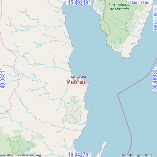
16° 10' 7.104" South, 49° 45' 58.392" East
| Map corner | latitude | longitude |
|---|---|---|
| Upper-left | -15.49219°, | 49.0631° |
| Center: | -16.16864°, | 49.76622° |
| Lower-right: | -16.84279°, | 50.46935° |
| Map W x H: | 150.2×150.2 km | = 93.3×93.3mi |
| max Lat: | -12.31732° ⇑17.1% North |
| Mananara: | -16.16864° |
| min Lat: | ⇓82.9% South -25.3° |
| min Long | Mananara | max Long |
| 43.65° | 49.76622° | 50.27876° |
| W 95.1%⇐ | ⇒4.9% E |
Elevation
Elevation of Mananara is 15 m = 49 ft, and this is 542.4 m = 1780 ft below average elevation for this country.
| Max E: |
1763 m = 5784 ft | 81.3% |
| Avg. | 557.4 m = 1829 ft | |
| Mananara | 15 m = 49 ft | |
Min E: |
1 m = 3 ft | 18.7% |
See also: Mananara elevation on elevation.city.
Geographical zone
Mananara is located in South Torrid zone (between Equator and Tropic of Capricorn). Distance of this Southern Tropic circle is 808.1 km =502.1 mi to South.| Distance of | km | miles | from Mananara |
|---|---|---|---|
| Equator | 1797.8 | 1117.1 | to North |
| Tropic Capricorn | 808.1 | 502.1 | to South |
| Antarctic Circle | 5603.4 | 3481.8 | to South |
| South Pole | 8209.3 | 5101 | to South |


Nearby cities:
15 places around Mananara: (largest is in red/bold)
• Ambodifotatra
91 km =56.5 mi,  174°
174°
• Ampahana
165 km =102.5 mi,  17°
17°
• Andapa
169.3 km =105.2 mi,  355°
355°
• Andilamena
157.9 km =98.1 mi,  233°
233°
• Antakotako
94.8 km =58.9 mi,  2°
2°
• Antalaha
151.3 km =94 mi, 21°
• Antsirabe Afovoany
88.8 km =55.2 mi,  285°
285°
• Bemaitso
167.8 km =104.3 mi, 233°
• Fenoarivo Atsinanana
140.1 km =87.1 mi,  195°
195°
• Mandritsara
106.1 km =65.9 mi, 289°
• Maroantsetra
81.6 km =50.7 mi, 357°
• Sahatavy
164.2 km =102 mi,  209°
209°
• Soanierana Ivongo
85.4 km =53.1 mi,  193°
193°
• Vavatenina
156.4 km =97.2 mi, 202°
• Vohibinany
152.8 km =94.9 mi, 210°
Sources, notices
• [Note1] Compared only with cities in Madagascar existing in our database
• [Src1] Map data: © OpenStreetMap contributors (CC-BY-SA)
• [Src2] Other city data from geonames.org with taken over terms of usage.
• [Src3] Geographical zone / Annual Mean Temperature by Robert A. Rohde @ Wikipedia
