Fenoarivo Atsinanana geodata
Fenoarivo Atsinanana (Analanjirofo) is a seat of a first-order administrative division; located in Madagascar in Indian/Antananarivo (GMT+3) time zone. With population of 21,036 people, there are 60 cities with bigger population in this country. Compared to other cities in Madagascar, 74% of cities are located further ↓South; 91.1% of cities are located further ←West and 82.9% of cities have higher elevation than Fenoarivo Atsinanana. Note1


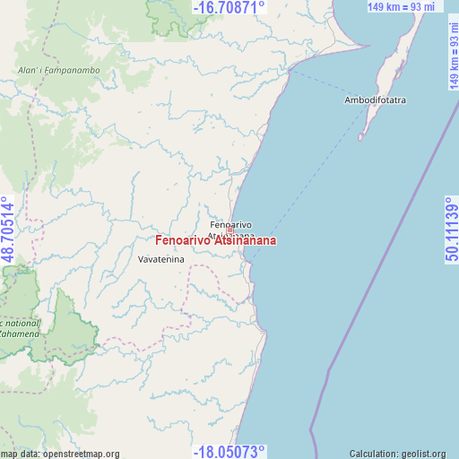
Fenoarivo Atsinanana GPS coordinates[2]
17° 22' 51.42" South, 49° 24' 29.736" East
| Map corner | latitude | longitude |
|---|---|---|
| Upper-left | -16.70871°, | 48.70514° |
| Center: | -17.38095°, | 49.40826° |
| Lower-right: | -18.05073°, | 50.11139° |
| Map W x H: | 149.2×149.2 km | = 92.7×92.7mi |
| max Lat: | -12.31732° ⇑26% North |
| Fenoarivo Atsinanana: | -17.38095° |
| min Lat: | ⇓74% South -25.3° |
| min Long | Fenoarivo Atsin | max Long |
| 43.65° | 49.40826° | 50.27876° |
| W 91.1%⇐ | ⇒8.9% E |
Elevation
Elevation of Fenoarivo Atsinanana is 14 m = 46 ft, and this is 543.4 m = 1783 ft below average elevation for this country.
| Max E: |
1763 m = 5784 ft | 82.9% |
| Avg. | 557.4 m = 1829 ft | |
| Fenoarivo Atsinanana | 14 m = 46 ft | |
Min E: |
1 m = 3 ft | 17.1% |
See also: Madagascar elevation on elevation.city.
Geographical zone
Fenoarivo Atsinanana is located in South Torrid zone (between Equator and Tropic of Capricorn). Distance of this Southern Tropic circle is 673.3 km =418.4 mi to South.| Distance of | km | miles | from Fenoarivo Atsinanana |
|---|---|---|---|
| Equator | 1932.6 | 1200.9 | to North |
| Tropic Capricorn | 673.3 | 418.4 | to South |
| Antarctic Circle | 5468.6 | 3398 | to South |
| South Pole | 8074.5 | 5017.3 | to South |


Nearby cities:
15 places around Fenoarivo Atsinanana: (largest is in red/bold)
• Ambatondrazaka
116.5 km =72.4 mi,  244°
244°
• Ambodifotatra
64.5 km =40.1 mi,  46°
46°
• Amparafaravola
127.7 km =79.3 mi,  259°
259°
• Ampasimanolotra
163.7 km =101.7 mi,  192°
192°
• Andilamena
97.8 km =60.8 mi,  294°
294°
• Andovoranto
177.8 km =110.5 mi, 190°
• Antsirabe Afovoany
165.9 km =103.1 mi,  343°
343°
• Bemaitso
102.6 km =63.8 mi, 289°
• Mahavelona
35.4 km =22 mi,  162°
162°
• Mananara
140.1 km =87.1 mi,  15°
15°
• Sahatavy
44 km =27.3 mi, 259°
• Soanierana Ivongo
54.9 km =34.1 mi, 19°
• Toamasina
85.4 km =53.1 mi,  180°
180°
• Vavatenina
24.1 km =15 mi,  246°
246°
• Vohibinany
39.9 km =24.8 mi,  274°
274°
Sources, notices
• [Note1] Compared only with cities in Madagascar existing in our database
• [Src1] Map data: © OpenStreetMap contributors (CC-BY-SA)
• [Src2] Other city data from geonames.org with taken over terms of usage.
• [Src3] Geographical zone / Annual Mean Temperature by Robert A. Rohde @ Wikipedia
