Mahavelona geodata
Mahavelona (Atsinanana) is a populated place; located in Madagascar in Indian/Antananarivo (GMT+3) time zone. With population of 7,987 people, there are 100 cities with bigger population in this country. Compared to other cities in Madagascar, 70.7% of cities are located further ↓South; 91.9% of cities are located further ←West and 89.4% of cities have higher elevation than Mahavelona. Note1
Administrative division(s):
- Level 1: Atsinanana
- Level 2: Toamasina II
- Level 3: Mahavelona (Foulpointe)
- Level 4: Foulpointe


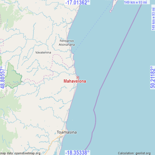
Mahavelona GPS coordinates[2]
17° 41' 5.1" South, 49° 30' 31.284" East
| Map corner | latitude | longitude |
|---|---|---|
| Upper-left | -17.01362°, | 48.80557° |
| Center: | -17.68475°, | 49.50869° |
| Lower-right: | -18.35338°, | 50.21182° |
| Map W x H: | 149×149 km | = 92.6×92.6mi |
| max Lat: | -12.31732° ⇑29.3% North |
| Mahavelona: | -17.68475° |
| min Lat: | ⇓70.7% South -25.3° |
| min Long | Mahavelona | max Long |
| 43.65° | 49.50869° | 50.27876° |
| W 91.9%⇐ | ⇒8.1% E |
Elevation
Elevation of Mahavelona is 11 m = 36 ft, and this is 546.4 m = 1793 ft below average elevation for this country.
| Max E: |
1763 m = 5784 ft | 89.4% |
| Avg. | 557.4 m = 1829 ft | |
| Mahavelona | 11 m = 36 ft | |
Min E: |
1 m = 3 ft | 10.6% |
See also: Madagascar elevation on elevation.city.
Geographical zone
Mahavelona is located in South Torrid zone (between Equator and Tropic of Capricorn). Distance of this Southern Tropic circle is 639.6 km =397.4 mi to South.| Distance of | km | miles | from Mahavelona |
|---|---|---|---|
| Equator | 1966.4 | 1221.9 | to North |
| Tropic Capricorn | 639.6 | 397.4 | to South |
| Antarctic Circle | 5434.8 | 3377 | to South |
| South Pole | 8040.7 | 4996.3 | to South |


Nearby cities:
15 places around Mahavelona: (largest is in red/bold)
• Ambatondrazaka
116.8 km =72.6 mi,  261°
261°
• Ambodifotatra
86 km =53.4 mi,  24°
24°
• Amparafaravola
136.6 km =84.9 mi,  274°
274°
• Ampasimanolotra
134.2 km =83.4 mi,  200°
200°
• Andilamena
124.4 km =77.3 mi,  307°
307°
• Andovoranto
147.3 km =91.5 mi, 196°
• Anjozorobe
190.9 km =118.6 mi,  245°
245°
• Bemaitso
127.2 km =79 mi,  302°
302°
• Fenoarivo Atsinanana
35.4 km =22 mi,  342°
342°
• Mananara
170.8 km =106.1 mi,  9°
9°
• Sahatavy
59.9 km =37.2 mi, 295°
• Soanierana Ivongo
85.8 km =53.3 mi, 5°
• Toamasina
52.9 km =32.9 mi,  192°
192°
• Vavatenina
40.7 km =25.3 mi, 306°
• Vohibinany
62.7 km =39 mi, 306°
Sources, notices
• [Note1] Compared only with cities in Madagascar existing in our database
• [Src1] Map data: © OpenStreetMap contributors (CC-BY-SA)
• [Src2] Other city data from geonames.org with taken over terms of usage.
• [Src3] Geographical zone / Annual Mean Temperature by Robert A. Rohde @ Wikipedia
