Ambodifotatra geodata
Ambodifotatra (Analanjirofo) is a populated place; located in Madagascar in Indian/Antananarivo (GMT+3) time zone. With population of 11,830 people, there are 88 cities with bigger population in this country. Compared to other cities in Madagascar, 78% of cities are located further ↓South; 96.7% of cities are located further ←West and 97.6% of cities have higher elevation than Ambodifotatra. Note1


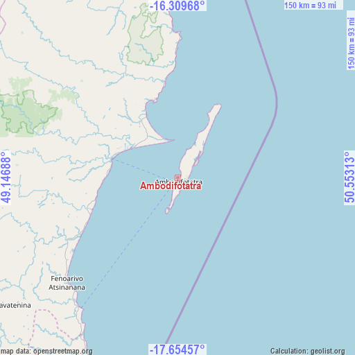
Ambodifotatra GPS coordinates[2]
16° 58' 59.988" South, 49° 51' 0" East
| Map corner | latitude | longitude |
|---|---|---|
| Upper-left | -16.30968°, | 49.14688° |
| Center: | -16.98333°, | 49.85° |
| Lower-right: | -17.65457°, | 50.55313° |
| Map W x H: | 149.5×149.5 km | = 92.9×92.9mi |
| max Lat: | -12.31732° ⇑22% North |
| Ambodifotatra: | -16.98333° |
| min Lat: | ⇓78% South -25.3° |
| min Long | Ambodifotatra | max Long |
| 43.65° | 49.85° | 50.27876° |
| W 96.7%⇐ | ⇒3.3% E |
Elevation
Elevation of Ambodifotatra is 5 m = 16 ft, and this is 552.4 m = 1812 ft below average elevation for this country.
| Max E: |
1763 m = 5784 ft | 97.6% |
| Avg. | 557.4 m = 1829 ft | |
| Ambodifotatra | 5 m = 16 ft | |
Min E: |
1 m = 3 ft | 2.4% |
See also: Madagascar elevation on elevation.city.
Geographical zone
Ambodifotatra is located in South Torrid zone (between Equator and Tropic of Capricorn). Distance of this Southern Tropic circle is 717.5 km =445.8 mi to South.| Distance of | km | miles | from Ambodifotatra |
|---|---|---|---|
| Equator | 1888.4 | 1173.4 | to North |
| Tropic Capricorn | 717.5 | 445.8 | to South |
| Antarctic Circle | 5512.8 | 3425.5 | to South |
| South Pole | 8118.7 | 5044.7 | to South |


Nearby cities:
15 places around Ambodifotatra: (largest is in red/bold)
• Ambatondrazaka
179 km =111.2 mi,  238°
238°
• Amparafaravola
185.3 km =115.1 mi,  248°
248°
• Andilamena
135.8 km =84.4 mi,  268°
268°
• Antsirabe Afovoany
148.6 km =92.3 mi,  320°
320°
• Bemaitso
143.8 km =89.4 mi, 266°
• Fenoarivo Atsinanana
64.5 km =40.1 mi,  226°
226°
• Mahavelona
86 km =53.4 mi,  204°
204°
• Mananara
91 km =56.5 mi,  354°
354°
• Mandritsara
166 km =103.1 mi, 318°
• Maroantsetra
172.5 km =107.2 mi,  356°
356°
• Sahatavy
104.1 km =64.7 mi, 240°
• Soanierana Ivongo
29.3 km =18.2 mi,  284°
284°
• Toamasina
138 km =85.7 mi, 200°
• Vavatenina
87.5 km =54.4 mi, 232°
• Vohibinany
95.9 km =59.6 mi, 244°
Sources, notices
• [Note1] Compared only with cities in Madagascar existing in our database
• [Src1] Map data: © OpenStreetMap contributors (CC-BY-SA)
• [Src2] Other city data from geonames.org with taken over terms of usage.
• [Src3] Geographical zone / Annual Mean Temperature by Robert A. Rohde @ Wikipedia
