Ambodivoara geodata
Ambodivoara (Sava) is a populated place; located in Madagascar in Indian/Antananarivo (GMT+3) time zone. With population of 10,000 people, there are 91 cities with bigger population in this country. Compared to other cities in Madagascar, 92.7% of cities are located further ↓South; 97.6% of cities are located further ←West and 69.9% of cities have higher elevation than Ambodivoara. Note1
Administrative division(s):
- Level 1: Sava
- Level 2: Sambava
- Level 3: Ambodivoara
- Level 4: Ambodivoara


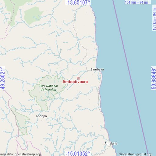
Ambodivoara GPS coordinates[2]
14° 19' 59.988" South, 49° 58' 59.988" East
| Map corner | latitude | longitude |
|---|---|---|
| Upper-left | -13.65107°, | 49.28021° |
| Center: | -14.33333°, | 49.98333° |
| Lower-right: | -15.01352°, | 50.68646° |
| Map W x H: | 151.5×151.5 km | = 94.1×94.1mi |
| max Lat: | -12.31732° ⇑7.3% North |
| Ambodivoara: | -14.33333° |
| min Lat: | ⇓92.7% South -25.3° |
| min Long | Ambodivoara | max Long |
| 43.65° | 49.98333° | 50.27876° |
| W 97.6%⇐ | ⇒2.4% E |
Elevation
Elevation of Ambodivoara is 43 m = 141 ft, and this is 514.4 m = 1688 ft below average elevation for this country.
| Max E: |
1763 m = 5784 ft | 69.9% |
| Avg. | 557.4 m = 1829 ft | |
| Ambodivoara | 43 m = 141 ft | |
Min E: |
1 m = 3 ft | 30.1% |
See also: Madagascar elevation on elevation.city.
Geographical zone
Ambodivoara is located in South Torrid zone (between Equator and Tropic of Capricorn). Distance of this Southern Tropic circle is 1012.2 km =629 mi to South.| Distance of | km | miles | from Ambodivoara |
|---|---|---|---|
| Equator | 1593.7 | 990.3 | to North |
| Tropic Capricorn | 1012.2 | 629 | to South |
| Antarctic Circle | 5807.5 | 3608.6 | to South |
| South Pole | 8413.3 | 5227.8 | to South |


Nearby cities:
15 places around Ambodivoara: (largest is in red/bold)
• Ambanja
180.9 km =112.4 mi,  294°
294°
• Ambarakaraka
152 km =94.4 mi,  307°
307°
• Ambilobe
161.4 km =100.3 mi,  321°
321°
• Ampahana
52.7 km =32.7 mi,  151°
151°
• Andapa
50.3 km =31.3 mi,  225°
225°
• Antakotako
111.1 km =69 mi,  190°
190°
• Antalaha
70.6 km =43.9 mi, 153°
• Antsirabe Afovoany
210.3 km =130.7 mi,  211°
211°
• Antsohimbondrona
185.2 km =115.1 mi, 318°
• Bealanana
134.9 km =83.8 mi,  260°
260°
• Mananara
205.4 km =127.6 mi, 186°
• Mandritsara
210 km =130.5 mi,  216°
216°
• Maroantsetra
125.3 km =77.9 mi, 192°
• Sadjoavato
202.8 km =126 mi,  340°
340°
• Sambava
21.1 km =13.1 mi,  69°
69°
Sources, notices
• [Note1] Compared only with cities in Madagascar existing in our database
• [Src1] Map data: © OpenStreetMap contributors (CC-BY-SA)
• [Src2] Other city data from geonames.org with taken over terms of usage.
• [Src3] Geographical zone / Annual Mean Temperature by Robert A. Rohde @ Wikipedia
