Antalaha geodata
Antalaha (Sava) is a populated place; located in Madagascar in Indian/Antananarivo (GMT+3) time zone. With population of 34,112 people, there are 23 cities with bigger population in this country. Compared to other cities in Madagascar, 88.6% of cities are located further ↓South; 100% of cities are located further ←West and 85.4% of cities have higher elevation than Antalaha. Note1
Administrative division(s):
- Level 1: Sava
- Level 2: Antalaha
- Level 3: Antalaha Ambonivohitra
- Level 4: Tanambao


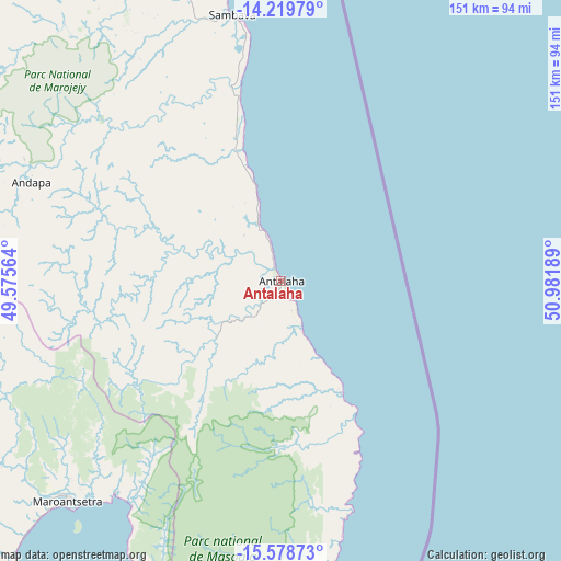
Antalaha GPS coordinates[2]
14° 54' 1.188" South, 50° 16' 43.536" East
| Map corner | latitude | longitude |
|---|---|---|
| Upper-left | -14.21979°, | 49.57564° |
| Center: | -14.90033°, | 50.27876° |
| Lower-right: | -15.57873°, | 50.98189° |
| Map W x H: | 151.1×151.1 km | = 93.9×93.9mi |
| max Lat: | -12.31732° ⇑11.4% North |
| Antalaha: | -14.90033° |
| min Lat: | ⇓88.6% South -25.3° |
| min Long | Antalaha | max Long |
| 43.65° | 50.27876° | 50.27876° |
| W 100%⇐ | ⇒0% E |
Elevation
Elevation of Antalaha is 13 m = 43 ft, and this is 544.4 m = 1786 ft below average elevation for this country.
| Max E: |
1763 m = 5784 ft | 85.4% |
| Avg. | 557.4 m = 1829 ft | |
| Antalaha | 13 m = 43 ft | |
Min E: |
1 m = 3 ft | 14.6% |
See also: Madagascar elevation on elevation.city.
Geographical zone
Antalaha is located in South Torrid zone (between Equator and Tropic of Capricorn). Distance of this Southern Tropic circle is 949.2 km =589.8 mi to South.| Distance of | km | miles | from Antalaha |
|---|---|---|---|
| Equator | 1656.8 | 1029.5 | to North |
| Tropic Capricorn | 949.2 | 589.8 | to South |
| Antarctic Circle | 5744.4 | 3569.4 | to South |
| South Pole | 8350.3 | 5188.6 | to South |


Nearby cities:
15 places around Antalaha: (largest is in red/bold)
• Ambanja
239.7 km =148.9 mi,  304°
304°
• Ambarakaraka
217.7 km =135.3 mi,  315°
315°
• Ambilobe
230.9 km =143.5 mi, 324°
• Ambodifotatra
236.1 km =146.7 mi,  191°
191°
• Ambodivoara
70.6 km =43.9 mi,  333°
333°
• Ampahana
18 km =11.2 mi,  338°
338°
• Andapa
73.1 km =45.4 mi,  292°
292°
• Antakotako
69.2 km =43 mi,  227°
227°
• Antsirabe Afovoany
182.8 km =113.6 mi, 230°
• Bealanana
169.1 km =105.1 mi,  283°
283°
• Mananara
151.3 km =94 mi,  201°
201°
• Mandritsara
188.4 km =117.1 mi,  235°
235°
• Maroantsetra
83.1 km =51.6 mi,  224°
224°
• Sambava
71.5 km =44.4 mi,  350°
350°
• Soanierana Ivongo
236.2 km =146.8 mi, 198°
Sources, notices
• [Note1] Compared only with cities in Madagascar existing in our database
• [Src1] Map data: © OpenStreetMap contributors (CC-BY-SA)
• [Src2] Other city data from geonames.org with taken over terms of usage.
• [Src3] Geographical zone / Annual Mean Temperature by Robert A. Rohde @ Wikipedia
