Ambanja geodata
Ambanja (Diana) is a populated place; located in Madagascar in Indian/Antananarivo (GMT+3) time zone. With population of 30,621 people, there are 31 cities with bigger population in this country. Compared to other cities in Madagascar, 94.3% of cities are located further ↓South; 74.8% of cities are located further ←West and 78% of cities have higher elevation than Ambanja. Note1


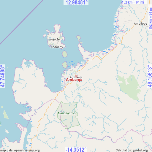
Ambanja GPS coordinates[2]
13° 40' 8.4" South, 48° 27' 10.8" East
| Map corner | latitude | longitude |
|---|---|---|
| Upper-left | -12.98481°, | 47.74988° |
| Center: | -13.669°, | 48.453° |
| Lower-right: | -14.3512°, | 49.15613° |
| Map W x H: | 151.9×151.9 km | = 94.4×94.4mi |
| max Lat: | -12.31732° ⇑5.7% North |
| Ambanja: | -13.669° |
| min Lat: | ⇓94.3% South -25.3° |
| min Long | Ambanja | max Long |
| 43.65° | 48.453° | 50.27876° |
| W 74.8%⇐ | ⇒25.2% E |
Elevation
Elevation of Ambanja is 20 m = 66 ft, and this is 537.4 m = 1763 ft below average elevation for this country.
| Max E: |
1763 m = 5784 ft | 78% |
| Avg. | 557.4 m = 1829 ft | |
| Ambanja | 20 m = 66 ft | |
Min E: |
1 m = 3 ft | 22% |
See also: Madagascar elevation on elevation.city.
Geographical zone
Ambanja is located in South Torrid zone (between Equator and Tropic of Capricorn). Distance of this Southern Tropic circle is 1086.1 km =674.9 mi to South.| Distance of | km | miles | from Ambanja |
|---|---|---|---|
| Equator | 1519.9 | 944.4 | to North |
| Tropic Capricorn | 1086.1 | 674.9 | to South |
| Antarctic Circle | 5881.3 | 3654.5 | to South |
| South Pole | 8487.2 | 5273.7 | to South |


Nearby cities:
15 places around Ambanja: (largest is in red/bold)
• Ambarakaraka
48.5 km =30.1 mi,  67°
67°
• Ambilobe
83 km =51.6 mi,  51°
51°
• Ambodivoara
180.9 km =112.4 mi,  114°
114°
• Ampahana
224.9 km =139.7 mi,  122°
122°
• Andapa
169 km =105 mi,  130°
130°
• Antakotako
233.6 km =145.2 mi,  141°
141°
• Antalaha
239.7 km =148.9 mi, 124°
• Antsiranana
175.6 km =109.1 mi,  31°
31°
• Antsohihy
143.6 km =89.2 mi,  200°
200°
• Antsohimbondrona
78 km =48.5 mi, 33°
• Bealanana
102.3 km =63.6 mi,  161°
161°
• Hell-Ville
36.3 km =22.6 mi,  326°
326°
• Mahalina
132.3 km =82.2 mi,  17°
17°
• Sadjoavato
152.1 km =94.5 mi,  39°
39°
• Sambava
196.5 km =122.1 mi, 109°
Sources, notices
• [Note1] Compared only with cities in Madagascar existing in our database
• [Src1] Map data: © OpenStreetMap contributors (CC-BY-SA)
• [Src2] Other city data from geonames.org with taken over terms of usage.
• [Src3] Geographical zone / Annual Mean Temperature by Robert A. Rohde @ Wikipedia
