Antakotako geodata
Antakotako (Analanjirofo) is a populated place; located in Madagascar in Indian/Antananarivo (GMT+3) time zone. With population of 11,000 people, there are 89 cities with bigger population in this country. Compared to other cities in Madagascar, 87.8% of cities are located further ↓South; 95.9% of cities are located further ←West and 65.9% of cities have higher elevation than Antakotako. Note1
Administrative division(s):
- Level 1: Analanjirofo
- Level 2: Maroantsetra District
- Level 3: Antakotako
- Level 4: Antakotako


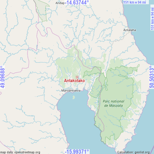
Antakotako GPS coordinates[2]
15° 19' 0.012" South, 49° 48' 0" East
| Map corner | latitude | longitude |
|---|---|---|
| Upper-left | -14.63744°, | 49.09688° |
| Center: | -15.31667°, | 49.8° |
| Lower-right: | -15.99371°, | 50.50313° |
| Map W x H: | 150.8×150.8 km | = 93.7×93.7mi |
| max Lat: | -12.31732° ⇑12.2% North |
| Antakotako: | -15.31667° |
| min Lat: | ⇓87.8% South -25.3° |
| min Long | Antakotako | max Long |
| 43.65° | 49.8° | 50.27876° |
| W 95.9%⇐ | ⇒4.1% E |
Elevation
Elevation of Antakotako is 62 m = 203 ft, and this is 495.4 m = 1625 ft below average elevation for this country.
| Max E: |
1763 m = 5784 ft | 65.9% |
| Avg. | 557.4 m = 1829 ft | |
| Antakotako | 62 m = 203 ft | |
Min E: |
1 m = 3 ft | 34.1% |
See also: Madagascar elevation on elevation.city.
Geographical zone
Antakotako is located in South Torrid zone (between Equator and Tropic of Capricorn). Distance of this Southern Tropic circle is 902.9 km =561 mi to South.| Distance of | km | miles | from Antakotako |
|---|---|---|---|
| Equator | 1703.1 | 1058.3 | to North |
| Tropic Capricorn | 902.9 | 561 | to South |
| Antarctic Circle | 5698.1 | 3540.6 | to South |
| South Pole | 8304 | 5159.9 | to South |


Nearby cities:
15 places around Antakotako: (largest is in red/bold)
• Ambarakaraka
225.6 km =140.2 mi,  333°
333°
• Ambodifotatra
185.4 km =115.2 mi,  178°
178°
• Ambodivoara
111.1 km =69 mi,  10°
10°
• Ampahana
77.3 km =48 mi,  35°
35°
• Andapa
75.9 km =47.2 mi,  347°
347°
• Andilamena
229.4 km =142.5 mi,  214°
214°
• Antalaha
69.2 km =43 mi,  47°
47°
• Antsirabe Afovoany
113.7 km =70.6 mi,  231°
231°
• Antsohihy
200.5 km =124.6 mi,  284°
284°
• Bealanana
141.9 km =88.2 mi,  307°
307°
• Mananara
94.8 km =58.9 mi, 182°
• Mandritsara
120.2 km =74.7 mi,  239°
239°
• Maroantsetra
14.8 km =9.2 mi, 206°
• Sambava
123.2 km =76.6 mi,  18°
18°
• Soanierana Ivongo
179.4 km =111.5 mi,  187°
187°
Sources, notices
• [Note1] Compared only with cities in Madagascar existing in our database
• [Src1] Map data: © OpenStreetMap contributors (CC-BY-SA)
• [Src2] Other city data from geonames.org with taken over terms of usage.
• [Src3] Geographical zone / Annual Mean Temperature by Robert A. Rohde @ Wikipedia
