Ambilobe geodata
Ambilobe (Diana) is a seat of a second-order administrative division; located in Madagascar in Indian/Antananarivo (GMT+3) time zone. With population of 56,000 people, there are 9 cities with bigger population in this country. Compared to other cities in Madagascar, 96.7% of cities are located further ↓South; 85.4% of cities are located further ←West and 72.4% of cities have higher elevation than Ambilobe. Note1


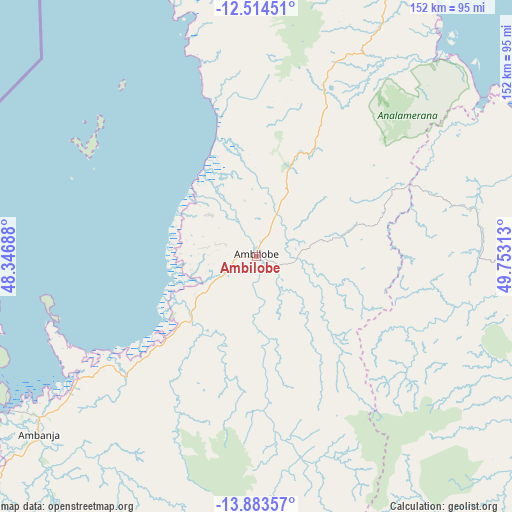
Ambilobe GPS coordinates[2]
13° 12' 0" South, 49° 3' 0" East
| Map corner | latitude | longitude |
|---|---|---|
| Upper-left | -12.51451°, | 48.34688° |
| Center: | -13.2°, | 49.05° |
| Lower-right: | -13.88357°, | 49.75313° |
| Map W x H: | 152.2×152.2 km | = 94.6×94.6mi |
| max Lat: | -12.31732° ⇑3.3% North |
| Ambilobe: | -13.2° |
| min Lat: | ⇓96.7% South -25.3° |
| min Long | Ambilobe | max Long |
| 43.65° | 49.05° | 50.27876° |
| W 85.4%⇐ | ⇒14.6% E |
Elevation
Elevation of Ambilobe is 31 m = 102 ft, and this is 526.4 m = 1727 ft below average elevation for this country.
| Max E: |
1763 m = 5784 ft | 72.4% |
| Avg. | 557.4 m = 1829 ft | |
| Ambilobe | 31 m = 102 ft | |
Min E: |
1 m = 3 ft | 27.6% |
See also: Ambilobe elevation on elevation.city.
Geographical zone
Ambilobe is located in South Torrid zone (between Equator and Tropic of Capricorn). Distance of this Southern Tropic circle is 1138.2 km =707.2 mi to South.| Distance of | km | miles | from Ambilobe |
|---|---|---|---|
| Equator | 1467.7 | 912 | to North |
| Tropic Capricorn | 1138.2 | 707.2 | to South |
| Antarctic Circle | 5933.5 | 3686.9 | to South |
| South Pole | 8539.4 | 5306.1 | to South |


Nearby cities:
15 places around Ambilobe: (largest is in red/bold)
• Ambanja
83 km =51.6 mi,  231°
231°
• Ambarakaraka
38.8 km =24.1 mi,  210°
210°
• Ambodivoara
161.4 km =100.3 mi,  141°
141°
• Ampahana
213.4 km =132.6 mi, 143°
• Andapa
173.7 km =107.9 mi,  158°
158°
• Antakotako
248.8 km =154.6 mi, 161°
• Antalaha
230.9 km =143.5 mi, 144°
• Antsiranana
101.6 km =63.1 mi,  14°
14°
• Antsohihy
219.1 km =136.1 mi, 211°
• Antsohimbondrona
25.2 km =15.7 mi,  300°
300°
• Bealanana
152.8 km =94.9 mi,  192°
192°
• Hell-Ville
87.6 km =54.4 mi,  255°
255°
• Mahalina
78.3 km =48.7 mi,  341°
341°
• Sadjoavato
72.6 km =45.1 mi,  26°
26°
• Sambava
169.2 km =105.1 mi,  134°
134°
Sources, notices
• [Note1] Compared only with cities in Madagascar existing in our database
• [Src1] Map data: © OpenStreetMap contributors (CC-BY-SA)
• [Src2] Other city data from geonames.org with taken over terms of usage.
• [Src3] Geographical zone / Annual Mean Temperature by Robert A. Rohde @ Wikipedia
