Myeik geodata
Myeik (Tanintharyi) is a populated place; located in Myanmar in Asia/Yangon (GMT+6.5) time zone. With population of 173,298 people, there are 10 cities with bigger population in this country. Compared to other cities in Myanmar, 98.6% of cities are located further ↑North; 98.6% of cities are located further ←West and 81.1% of cities have higher elevation than Myeik. Note1


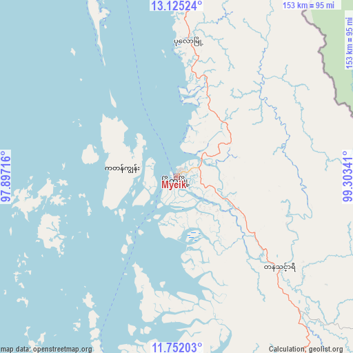
Myeik GPS coordinates[2]
12° 26' 22.344" North, 98° 36' 1.008" East
| Map corner | latitude | longitude |
|---|---|---|
| Upper-left | 13.12524°, | 97.89716° |
| Center: | 12.43954°, | 98.60028° |
| Lower-right: | 11.75203°, | 99.30341° |
| Map W x H: | 152.7×152.7 km | = 94.9×94.9mi |
| max Lat: | 25.38327° ⇑98.6% North |
| Myeik: | 12.43954° |
| min Lat: | ⇓1.4% South 9.98238° |
| min Long | Myeik | max Long |
| 92.89835° | 98.60028° | 99.88083° |
| W 98.6%⇐ | ⇒1.4% E |
Elevation
Elevation of Myeik is 15 m = 49 ft, and this is 173.9 m = 571 ft below average elevation for this country.
| Max E: |
1768 m = 5801 ft | 81.1% |
| Avg. | 188.9 m = 620 ft | |
| Myeik | 15 m = 49 ft | |
Min E: |
5 m = 16 ft | 18.9% |
See also: Myeik elevation on elevation.city.
Geographical zone
Myeik is located in North Torrid zone (between Equator and Tropic of Cancer). Distance of this Northern Tropic circle is 1222.8 km =759.8 mi to North.| Distance of | km | miles | from Myeik |
|---|---|---|---|
| North Pole | 8623.9 | 5358.6 | to North |
| Arctic Circle | 6018 | 3739.4 | to North |
| Tropic Cancer | 1222.8 | 759.8 | to North |
| Equator | 1383.1 | 859.4 | to South |


Nearby cities:
11 places around Myeik: (largest is in red/bold)
• Dawei
187.9 km =116.8 mi,  346°
346°
• Dellok
407.1 km =253 mi, 349°
• Kawthoung
273.3 km =169.8 mi,  181°
181°
• Klonhtoug
391.2 km =243.1 mi,  357°
357°
• Kyaikkami
419.6 km =260.7 mi,  344°
344°
• Kyain Seikgyi Township
378.1 km =234.9 mi, 354°
• Mikenaungea
391.7 km =243.4 mi, 357°
• Mudon
434.7 km =270.1 mi, 347°
• Pulei
410.2 km =254.9 mi, 349°
• Tagondaing
410.3 km =254.9 mi, 349°
• Tamoowoug
406.5 km =252.6 mi, 349°
Sources, notices
• [Note1] Compared only with cities in Myanmar existing in our database
• [Src1] Map data: © OpenStreetMap contributors (CC-BY-SA)
• [Src2] Other city data from geonames.org with taken over terms of usage.
• [Src3] Geographical zone / Annual Mean Temperature by Robert A. Rohde @ Wikipedia
