Pulei geodata
Pulei (Kayin) is a populated place; located in Myanmar in Asia/Yangon (GMT+6.5) time zone. With population of 2,001 people, there are 70 cities with bigger population in this country. Compared to other cities in Myanmar, 89.2% of cities are located further ↑North; 85.1% of cities are located further ←West and 70.3% of cities have higher elevation than Pulei. Note1
Administrative division(s):
- Level 1: Kayin
- Level 2: Kawkareik District
- Level 3: Kyain Seikgyi Township


Pulei GPS coordinates[2]
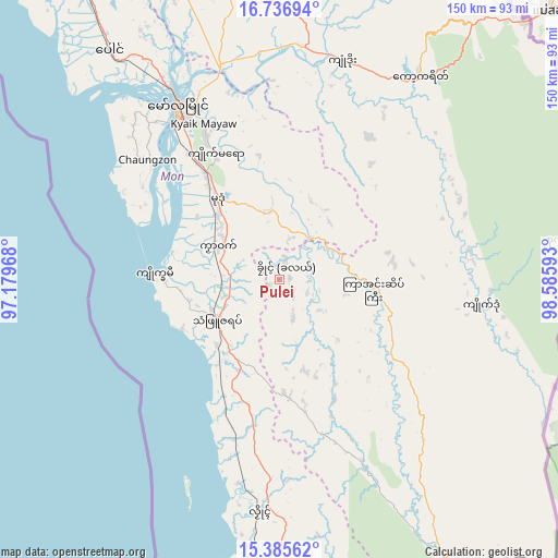
16° 3' 44.748" North, 97° 52' 58.08" East
| Map corner | latitude | longitude |
|---|---|---|
| Upper-left | 16.73694°, | 97.17968° |
| Center: | 16.06243°, | 97.8828° |
| Lower-right: | 15.38562°, | 98.58593° |
| Map W x H: | 150.3×150.3 km | = 93.4×93.4mi |
| max Lat: | 25.38327° ⇑89.2% North |
| Pulei: | 16.06243° |
| min Lat: | ⇓10.8% South 9.98238° |
| min Long | Pulei | max Long |
| 92.89835° | 97.8828° | 99.88083° |
| W 85.1%⇐ | ⇒14.9% E |
Elevation
Elevation of Pulei is 19 m = 62 ft, and this is 169.9 m = 557 ft below average elevation for this country.
| Max E: |
1768 m = 5801 ft | 70.3% |
| Avg. | 188.9 m = 620 ft | |
| Pulei | 19 m = 62 ft | |
Min E: |
5 m = 16 ft | 29.7% |
See also: Myanmar elevation on elevation.city.
Geographical zone
Pulei is located in North Torrid zone (between Equator and Tropic of Cancer). Distance of this Northern Tropic circle is 819.9 km =509.5 mi to North.| Distance of | km | miles | from Pulei |
|---|---|---|---|
| North Pole | 8221.1 | 5108.4 | to North |
| Arctic Circle | 5615.2 | 3489.1 | to North |
| Tropic Cancer | 819.9 | 509.5 | to North |
| Equator | 1786 | 1109.8 | to South |


Nearby cities:
15 places around Pulei: (largest is in red/bold)
• Dellok
4.4 km =2.7 mi,  122°
122°
• Hpa-An
95.7 km =59.5 mi,  343°
343°
• Klonhtoug
60 km =37.3 mi,  101°
101°
• Kyaikkami
34.1 km =21.2 mi,  272°
272°
• Kyaikto
166.8 km =103.6 mi,  326°
326°
• Kyain Seikgyi Township
47.7 km =29.6 mi, 123°
• Martaban
59.1 km =36.7 mi, 331°
• Mawlamyine
54.8 km =34.1 mi, 330°
• Mikenaungea
59.3 km =36.8 mi, 101°
• Mudon
27.4 km =17 mi,  321°
321°
• Myawadi
96.5 km =60 mi,  43°
43°
• Tagondaing
2.6 km =1.6 mi,  77°
77°
• Tamoowoug
4.6 km =2.9 mi,  132°
132°
• Thaton
109.8 km =68.2 mi, 330°
• Thongwa
164.3 km =102.1 mi,  298°
298°
Sources, notices
• [Note1] Compared only with cities in Myanmar existing in our database
• [Src1] Map data: © OpenStreetMap contributors (CC-BY-SA)
• [Src2] Other city data from geonames.org with taken over terms of usage.
• [Src3] Geographical zone / Annual Mean Temperature by Robert A. Rohde @ Wikipedia
