Dawei geodata
Dawei (Tanintharyi) is a seat of a first-order administrative division; located in Myanmar in Asia/Yangon (GMT+6.5) time zone. With population of 136,783 people, there are 13 cities with bigger population in this country. Compared to other cities in Myanmar, 97.3% of cities are located further ↑North; 90.5% of cities are located further ←West and 78.4% of cities have higher elevation than Dawei. Note1


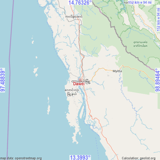
Dawei GPS coordinates[2]
14° 4' 56.28" North, 98° 11' 29.436" East
| Map corner | latitude | longitude |
|---|---|---|
| Upper-left | 14.76326°, | 97.48839° |
| Center: | 14.0823°, | 98.19151° |
| Lower-right: | 13.3993°, | 98.89464° |
| Map W x H: | 151.7×151.7 km | = 94.3×94.3mi |
| max Lat: | 25.38327° ⇑97.3% North |
| Dawei: | 14.0823° |
| min Lat: | ⇓2.7% South 9.98238° |
| min Long | Dawei | max Long |
| 92.89835° | 98.19151° | 99.88083° |
| W 90.5%⇐ | ⇒9.5% E |
Elevation
Elevation of Dawei is 17 m = 56 ft, and this is 171.9 m = 564 ft below average elevation for this country.
| Max E: |
1768 m = 5801 ft | 78.4% |
| Avg. | 188.9 m = 620 ft | |
| Dawei | 17 m = 56 ft | |
Min E: |
5 m = 16 ft | 21.6% |
See also: Dawei elevation on elevation.city.
Geographical zone
Dawei is located in North Torrid zone (between Equator and Tropic of Cancer). Distance of this Northern Tropic circle is 1040.1 km =646.3 mi to North.| Distance of | km | miles | from Dawei |
|---|---|---|---|
| North Pole | 8441.3 | 5245.2 | to North |
| Arctic Circle | 5835.4 | 3625.9 | to North |
| Tropic Cancer | 1040.1 | 646.3 | to North |
| Equator | 1565.8 | 972.9 | to South |


Nearby cities:
15 places around Dawei: (largest is in red/bold)
• Dellok
219.7 km =136.5 mi,  352°
352°
• Hpa-An
317.8 km =197.5 mi, 349°
• Klonhtoug
209.7 km =130.3 mi,  7°
7°
• Kyaikkami
231.8 km =144 mi,  343°
343°
• Kyain Seikgyi Township
193.6 km =120.3 mi,  1°
1°
• Martaban
278.9 km =173.3 mi, 347°
• Mawlamyine
274.5 km =170.6 mi, 347°
• Mikenaungea
210.1 km =130.6 mi, 6°
• Mudon
246.9 km =153.4 mi, 348°
• Myawadi
291.8 km =181.3 mi, 6°
• Myeik
187.9 km =116.8 mi,  166°
166°
• Pulei
222.7 km =138.4 mi, 351°
• Tagondaing
222.8 km =138.4 mi, 352°
• Tamoowoug
219.1 km =136.1 mi, 352°
• Thaton
327.4 km =203.4 mi, 344°
Sources, notices
• [Note1] Compared only with cities in Myanmar existing in our database
• [Src1] Map data: © OpenStreetMap contributors (CC-BY-SA)
• [Src2] Other city data from geonames.org with taken over terms of usage.
• [Src3] Geographical zone / Annual Mean Temperature by Robert A. Rohde @ Wikipedia
