Uujim geodata
Uujim (Bayan-Ölgiy) is a seat of a second-order administrative division; located in Mongolia in Asia/Hovd (GMT+7) time zone. In our database, there are 33 cities with bigger population. Compared to other cities in Mongolia, 74.8% of cities are located further ↓South; 98.8% of cities are located further →East and 77.9% of cities have lower elevation than Uujim. Note1


Uujim GPS coordinates[2]
48° 54' 0" North, 89° 37' 0.012" East
| Map corner | latitude | longitude |
|---|---|---|
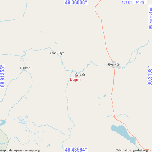
| Upper-left | 49.36008°, | 88.91355° |
| Center: | 48.9°, | 89.61667° |
| Lower-right: | 48.43564°, | 90.3198° |
| Map W x H: | 102.8×102.8 km | = 63.9×63.9mi |
| max Lat: | 51.50725° ⇑25.2% North |
| Uujim: | 48.9° |
| min Lat: | ⇓74.8% South 42.84199° |
| min Long | Uujim | max Long |
| 89.14358° | 89.61667° | 118.51014° |
| W 1.2%⇐ | ⇒98.8% E |
Elevation
Elevation of Uujim is 1755 m = 5758 ft, and this is 338.5 m = 1111 ft above average elevation for this country.
| Max E: |
2800 m = 9186 ft | 22.1% |
| Uujim | 1755 m 5758 ft | |
| Avg. | 1416.5 m = 4647 ft | |
Min E: |
619 m = 2031 ft | 77.9% |
See also: Mongolia elevation on elevation.city.
Geographical zone
Uujim is located in North temperate zone (between Tropic of Cancer and the Arctic Circle). Distance of this North polar circle is 1964 km =1220.4 mi to North.| Distance of | km | miles | from Uujim |
|---|---|---|---|
| North Pole | 4569.9 | 2839.6 | to North |
| Arctic Circle | 1964 | 1220.4 | to North |
| Tropic Cancer | 2831.3 | 1759.3 | to South |
| Equator | 5437.2 | 3378.5 | to South |


Nearby cities:
15 places around Uujim: (largest is in red/bold)
• Bayshint
98 km =60.9 mi,  29°
29°
• Bilüü
20.6 km =12.8 mi,  320°
320°
• Buga
27.4 km =17 mi,  78°
78°
• Buyant
36 km =22.4 mi,  188°
188°
• Chihertey
66.8 km =41.5 mi, 186°
• Har-Us
141.2 km =87.7 mi,  109°
109°
• Höhtolgoy
103.2 km =64.1 mi,  65°
65°
• Höshööt
35 km =21.7 mi,  278°
278°
• Namir
155 km =96.3 mi, 81°
• Nogoonnuur
91.7 km =57 mi, 29°
• Rashaant
154.8 km =96.2 mi,  144°
144°
• Tolbo
72.7 km =45.2 mi, 137°
• Tsagaantüngi
63.1 km =39.2 mi, 74°
• Ulaan Khat
103.4 km =64.2 mi,  170°
170°
• Ölgii
26.4 km =16.4 mi, 73°
Sources, notices
• [Note1] Compared only with cities in Mongolia existing in our database
• [Src1] Map data: © OpenStreetMap contributors (CC-BY-SA)
• [Src2] Other city data from geonames.org with taken over terms of usage.
• [Src3] Geographical zone / Annual Mean Temperature by Robert A. Rohde @ Wikipedia
