Bilüü geodata
Bilüü (Bayan-Ölgiy) is a seat of a second-order administrative division; located in Mongolia in Asia/Hovd (GMT+7) time zone. In our database, there are 33 cities with bigger population. Compared to other cities in Mongolia, 78.2% of cities are located further ↓South; 99.7% of cities are located further →East and 79.1% of cities have lower elevation than Bilüü. Note1


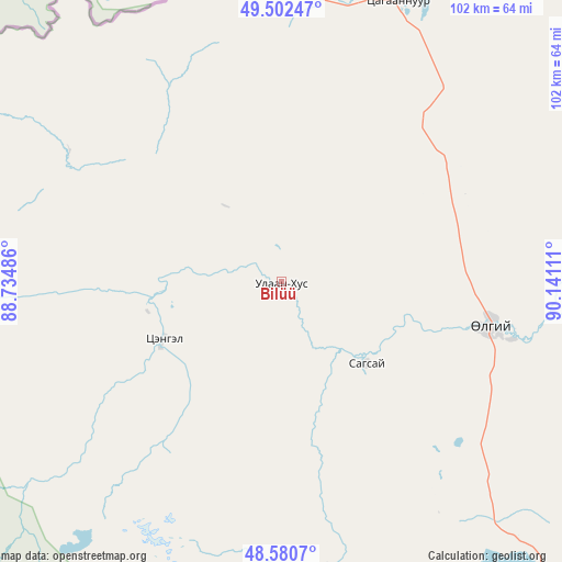
Bilüü GPS coordinates[2]
49° 2' 37.392" North, 89° 26' 16.728" East
| Map corner | latitude | longitude |
|---|---|---|
| Upper-left | 49.50247°, | 88.73486° |
| Center: | 49.04372°, | 89.43798° |
| Lower-right: | 48.5807°, | 90.14111° |
| Map W x H: | 102.5×102.5 km | = 63.7×63.7mi |
| max Lat: | 51.50725° ⇑21.8% North |
| Bilüü: | 49.04372° |
| min Lat: | ⇓78.2% South 42.84199° |
| min Long | Bilüü | max Long |
| 89.14358° | 89.43798° | 118.51014° |
| W 0.3%⇐ | ⇒99.7% E |
Elevation
Elevation of Bilüü is 1772 m = 5814 ft, and this is 355.5 m = 1166 ft above average elevation for this country.
| Max E: |
2800 m = 9186 ft | 20.9% |
| Bilüü | 1772 m 5814 ft | |
| Avg. | 1416.5 m = 4647 ft | |
Min E: |
619 m = 2031 ft | 79.1% |
See also: Mongolia elevation on elevation.city.
Geographical zone
Bilüü is located in North temperate zone (between Tropic of Cancer and the Arctic Circle). Distance of this North polar circle is 1948 km =1210.4 mi to North.| Distance of | km | miles | from Bilüü |
|---|---|---|---|
| North Pole | 4553.9 | 2829.7 | to North |
| Arctic Circle | 1948 | 1210.4 | to North |
| Tropic Cancer | 2847.2 | 1769.2 | to South |
| Equator | 5453.2 | 3388.5 | to South |


Nearby cities:
15 places around Bilüü: (largest is in red/bold)
• Bayshint
92.4 km =57.4 mi,  41°
41°
• Buga
41.1 km =25.5 mi,  104°
104°
• Buyant
52.2 km =32.4 mi,  171°
171°
• Chihertey
82.6 km =51.3 mi,  176°
176°
• Har-Us
159 km =98.8 mi,  113°
113°
• Höhtolgoy
110.2 km =68.5 mi,  76°
76°
• Höshööt
24 km =14.9 mi,  243°
243°
• Namir
166.2 km =103.3 mi,  87°
87°
• Nogoonnuur
86.3 km =53.6 mi, 42°
• Rashaant
175.4 km =109 mi,  144°
144°
• Tolbo
93.3 km =58 mi, 138°
• Tsagaantüngi
73.8 km =45.9 mi, 89°
• Ulaan Khat
121.7 km =75.6 mi, 165°
• Uujim
20.6 km =12.8 mi, 140°
• Ölgii
39.2 km =24.4 mi, 102°
Sources, notices
• [Note1] Compared only with cities in Mongolia existing in our database
• [Src1] Map data: © OpenStreetMap contributors (CC-BY-SA)
• [Src2] Other city data from geonames.org with taken over terms of usage.
• [Src3] Geographical zone / Annual Mean Temperature by Robert A. Rohde @ Wikipedia
