Ölgii geodata
Ölgii (Bayan-Ölgiy) is a seat of a first-order administrative division; located in Mongolia in Asia/Hovd (GMT+7) time zone. With population of 28,400 people, there are 4 cities with bigger population in this country. Compared to other cities in Mongolia, 76.4% of cities are located further ↓South; 98.2% of cities are located further →East and 76.4% of cities have lower elevation than Ölgii. Note1


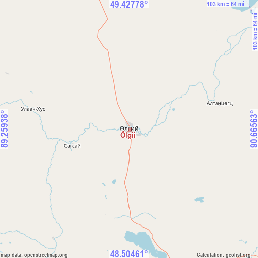
Ölgii GPS coordinates[2]
48° 58' 5.988" North, 89° 57' 45" East
| Map corner | latitude | longitude |
|---|---|---|
| Upper-left | 49.42778°, | 89.25938° |
| Center: | 48.96833°, | 89.9625° |
| Lower-right: | 48.50461°, | 90.66563° |
| Map W x H: | 102.6×102.6 km | = 63.8×63.8mi |
| max Lat: | 51.50725° ⇑23.6% North |
| Ölgii: | 48.96833° |
| min Lat: | ⇓76.4% South 42.84199° |
| min Long | Ölgii | max Long |
| 89.14358° | 89.9625° | 118.51014° |
| W 1.8%⇐ | ⇒98.2% E |
Elevation
Elevation of Ölgii is 1715 m = 5627 ft, and this is 298.5 m = 979 ft above average elevation for this country.
| Max E: |
2800 m = 9186 ft | 23.6% |
| Ölgii | 1715 m 5627 ft | |
| Avg. | 1416.5 m = 4647 ft | |
Min E: |
619 m = 2031 ft | 76.4% |
See also: Mongolia elevation on elevation.city.
Geographical zone
Ölgii is located in North temperate zone (between Tropic of Cancer and the Arctic Circle). Distance of this North polar circle is 1956.4 km =1215.7 mi to North.| Distance of | km | miles | from Ölgii |
|---|---|---|---|
| North Pole | 4562.3 | 2834.9 | to North |
| Arctic Circle | 1956.4 | 1215.7 | to North |
| Tropic Cancer | 2838.8 | 1763.9 | to South |
| Equator | 5444.8 | 3383.2 | to South |


Nearby cities:
15 places around Ölgii: (largest is in red/bold)
• Bayshint
81.1 km =50.4 mi,  16°
16°
• Bilüü
39.2 km =24.4 mi,  282°
282°
• Buga
2.5 km =1.6 mi,  143°
143°
• Buyant
52.8 km =32.8 mi,  215°
215°
• Chihertey
81 km =50.3 mi,  203°
203°
• Har-Us
120.6 km =74.9 mi,  116°
116°
• Höhtolgoy
77.2 km =48 mi,  63°
63°
• Höshööt
59.8 km =37.2 mi,  267°
267°
• Namir
128.9 km =80.1 mi,  83°
83°
• Nogoonnuur
74.8 km =46.5 mi, 15°
• Rashaant
148.3 km =92.1 mi,  154°
154°
• Tolbo
65.7 km =40.8 mi,  158°
158°
• Tsagaantüngi
36.7 km =22.8 mi, 75°
• Ulaan Khat
110 km =68.4 mi,  184°
184°
• Uujim
26.4 km =16.4 mi,  253°
253°
Sources, notices
• [Note1] Compared only with cities in Mongolia existing in our database
• [Src1] Map data: © OpenStreetMap contributors (CC-BY-SA)
• [Src2] Other city data from geonames.org with taken over terms of usage.
• [Src3] Geographical zone / Annual Mean Temperature by Robert A. Rohde @ Wikipedia
