Nogoonnuur geodata
Nogoonnuur (Bayan-Ölgiy) is a seat of a second-order administrative division; located in Mongolia in Asia/Hovd (GMT+7) time zone. In our database, there are 33 cities with bigger population. Compared to other cities in Mongolia, 89% of cities are located further ↓South; 97.5% of cities are located further →East and 60.7% of cities have lower elevation than Nogoonnuur. Note1


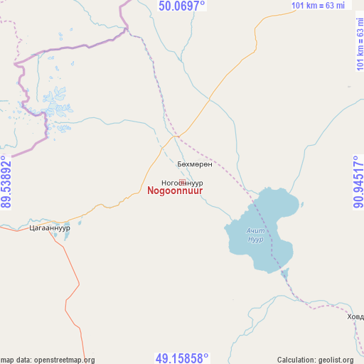
Nogoonnuur GPS coordinates[2]
49° 36' 58.572" North, 90° 14' 31.344" East
| Map corner | latitude | longitude |
|---|---|---|
| Upper-left | 50.0697°, | 89.53892° |
| Center: | 49.61627°, | 90.24204° |
| Lower-right: | 49.15858°, | 90.94517° |
| Map W x H: | 101.3×101.3 km | = 62.9×62.9mi |
| max Lat: | 51.50725° ⇑11% North |
| Nogoonnuur: | 49.61627° |
| min Lat: | ⇓89% South 42.84199° |
| min Long | Nogoonnuur | max Long |
| 89.14358° | 90.24204° | 118.51014° |
| W 2.5%⇐ | ⇒97.5% E |
Elevation
Elevation of Nogoonnuur is 1484 m = 4869 ft, and this is 67.5 m = 221 ft above average elevation for this country.
| Max E: |
2800 m = 9186 ft | 39.3% |
| Nogoonnuur | 1484 m 4869 ft | |
| Avg. | 1416.5 m = 4647 ft | |
Min E: |
619 m = 2031 ft | 60.7% |
See also: Mongolia elevation on elevation.city.
Geographical zone
Nogoonnuur is located in North temperate zone (between Tropic of Cancer and the Arctic Circle). Distance of this North polar circle is 1884.4 km =1170.9 mi to North.| Distance of | km | miles | from Nogoonnuur |
|---|---|---|---|
| North Pole | 4490.2 | 2790.1 | to North |
| Arctic Circle | 1884.4 | 1170.9 | to North |
| Tropic Cancer | 2910.9 | 1808.7 | to South |
| Equator | 5516.8 | 3428 | to South |


Nearby cities:
15 places around Nogoonnuur: (largest is in red/bold)
• Bayshint
6.3 km =3.9 mi,  27°
27°
• Bilüü
86.3 km =53.6 mi,  222°
222°
• Buga
76.4 km =47.5 mi,  194°
194°
• Buyant
125.9 km =78.2 mi,  203°
203°
• Harhiraa
120.9 km =75.1 mi,  81°
81°
• Harmod
126.6 km =78.7 mi,  50°
50°
• Havtsal
115.4 km =71.7 mi,  62°
62°
• Höhtolgoy
61.1 km =38 mi,  127°
127°
• Höshööt
109 km =67.7 mi,  226°
226°
• Namir
121 km =75.2 mi,  117°
117°
• Tolbo
133.4 km =82.9 mi,  178°
178°
• Tsagaantüngi
64.7 km =40.2 mi,  166°
166°
• Ulaangom
137.1 km =85.2 mi,  72°
72°
• Uujim
91.7 km =57 mi,  209°
209°
• Ölgii
74.8 km =46.5 mi, 195°
Sources, notices
• [Note1] Compared only with cities in Mongolia existing in our database
• [Src1] Map data: © OpenStreetMap contributors (CC-BY-SA)
• [Src2] Other city data from geonames.org with taken over terms of usage.
• [Src3] Geographical zone / Annual Mean Temperature by Robert A. Rohde @ Wikipedia
