Ulaangom geodata
Ulaangom (Uvs) is a seat of a first-order administrative division; located in Mongolia in Asia/Hovd (GMT+7) time zone. With population of 28,085 people, there are 5 cities with bigger population in this country. Compared to other cities in Mongolia, 94.2% of cities are located further ↓South; 91.7% of cities are located further →East and 88.3% of cities have higher elevation than Ulaangom. Note1


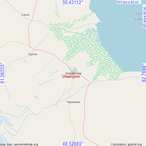
Ulaangom GPS coordinates[2]
49° 58' 51.996" North, 92° 4' 0.012" East
| Map corner | latitude | longitude |
|---|---|---|
| Upper-left | 50.43112°, | 91.36355° |
| Center: | 49.98111°, | 92.06667° |
| Lower-right: | 49.52685°, | 92.7698° |
| Map W x H: | 100.5×100.5 km | = 62.4×62.4mi |
| max Lat: | 51.50725° ⇑5.8% North |
| Ulaangom: | 49.98111° |
| min Lat: | ⇓94.2% South 42.84199° |
| min Long | Ulaangom | max Long |
| 89.14358° | 92.06667° | 118.51014° |
| W 8.3%⇐ | ⇒91.7% E |
Elevation
Elevation of Ulaangom is 935 m = 3068 ft, and this is 481.5 m = 1580 ft below average elevation for this country.
| Max E: |
2800 m = 9186 ft | 88.3% |
| Avg. | 1416.5 m = 4647 ft | |
| Ulaangom | 935 m = 3068 ft | |
Min E: |
619 m = 2031 ft | 11.7% |
See also: Mongolia elevation on elevation.city.
Geographical zone
Ulaangom is located in North temperate zone (between Tropic of Cancer and the Arctic Circle). Distance of this North polar circle is 1843.8 km =1145.7 mi to North.| Distance of | km | miles | from Ulaangom |
|---|---|---|---|
| North Pole | 4449.7 | 2764.9 | to North |
| Arctic Circle | 1843.8 | 1145.7 | to North |
| Tropic Cancer | 2951.5 | 1834 | to South |
| Equator | 5557.4 | 3453.2 | to South |


Nearby cities:
15 places around Ulaangom: (largest is in red/bold)
• Bayshint
132.6 km =82.4 mi,  254°
254°
• Bugat
135.2 km =84 mi,  111°
111°
• Dzel
123.3 km =76.6 mi,  93°
93°
• Dzüünhövöö
73.9 km =45.9 mi,  18°
18°
• Har-Us
105.4 km =65.5 mi,  181°
181°
• Harhiraa
25.4 km =15.8 mi,  207°
207°
• Harmod
51.8 km =32.2 mi,  320°
320°
• Havtsal
31.5 km =19.6 mi,  294°
294°
• Höhtolgoy
114.1 km =70.9 mi,  226°
226°
• Namir
100.5 km =62.4 mi,  194°
194°
• Naranbulag
77.2 km =48 mi,  152°
152°
• Nogoonnuur
137.1 km =85.2 mi, 252°
• Sharbulag
149.5 km =92.9 mi, 149°
• Tooromt
120.6 km =74.9 mi,  63°
63°
• Tsalgar
90.9 km =56.5 mi, 108°
Sources, notices
• [Note1] Compared only with cities in Mongolia existing in our database
• [Src1] Map data: © OpenStreetMap contributors (CC-BY-SA)
• [Src2] Other city data from geonames.org with taken over terms of usage.
• [Src3] Geographical zone / Annual Mean Temperature by Robert A. Rohde @ Wikipedia
