Harhiraa geodata
Harhiraa (Uvs) is a seat of a second-order administrative division; located in Mongolia in Asia/Hovd (GMT+7) time zone. In our database, there are 33 cities with bigger population. Compared to other cities in Mongolia, 91.7% of cities are located further ↓South; 92.9% of cities are located further →East and 50.3% of cities have lower elevation than Harhiraa. Note1


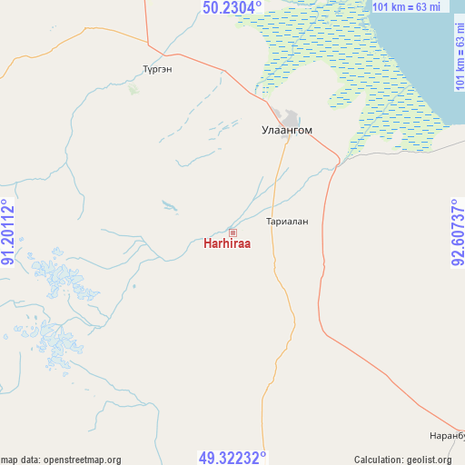
Harhiraa GPS coordinates[2]
49° 46' 42.564" North, 91° 54' 15.264" East
| Map corner | latitude | longitude |
|---|---|---|
| Upper-left | 50.2304°, | 91.20112° |
| Center: | 49.77849°, | 91.90424° |
| Lower-right: | 49.32232°, | 92.60737° |
| Map W x H: | 101×101 km | = 62.8×62.8mi |
| max Lat: | 51.50725° ⇑8.3% North |
| Harhiraa: | 49.77849° |
| min Lat: | ⇓91.7% South 42.84199° |
| min Long | Harhiraa | max Long |
| 89.14358° | 91.90424° | 118.51014° |
| W 7.1%⇐ | ⇒92.9% E |
Elevation
Elevation of Harhiraa is 1392 m = 4567 ft, and this is 24.5 m = 80 ft below average elevation for this country.
| Max E: |
2800 m = 9186 ft | 49.7% |
| Avg. | 1416.5 m = 4647 ft | |
| Harhiraa | 1392 m = 4567 ft | |
Min E: |
619 m = 2031 ft | 50.3% |
See also: Mongolia elevation on elevation.city.
Geographical zone
Harhiraa is located in North temperate zone (between Tropic of Cancer and the Arctic Circle). Distance of this North polar circle is 1866.3 km =1159.7 mi to North.| Distance of | km | miles | from Harhiraa |
|---|---|---|---|
| North Pole | 4472.2 | 2778.9 | to North |
| Arctic Circle | 1866.3 | 1159.7 | to North |
| Tropic Cancer | 2928.9 | 1819.9 | to South |
| Equator | 5534.8 | 3439.2 | to South |


Nearby cities:
15 places around Harhiraa: (largest is in red/bold)
• Bayshint
117.2 km =72.8 mi,  263°
263°
• Bugat
140.3 km =87.2 mi,  101°
101°
• Dzel
135.7 km =84.3 mi,  83°
83°
• Dzüünhövöö
99 km =61.5 mi,  20°
20°
• Har-Us
83.4 km =51.8 mi,  173°
173°
• Harmod
66.1 km =41.1 mi,  341°
341°
• Havtsal
39.6 km =24.6 mi,  334°
334°
• Höhtolgoy
90.7 km =56.4 mi,  232°
232°
• Namir
75.9 km =47.2 mi,  190°
190°
• Naranbulag
66.2 km =41.1 mi,  133°
133°
• Nogoonnuur
120.9 km =75.1 mi, 261°
• Sharbulag
137.7 km =85.6 mi,  140°
140°
• Tsagaantüngi
132.8 km =82.5 mi, 232°
• Tsalgar
98.1 km =61 mi,  94°
94°
• Ulaangom
25.4 km =15.8 mi,  27°
27°
Sources, notices
• [Note1] Compared only with cities in Mongolia existing in our database
• [Src1] Map data: © OpenStreetMap contributors (CC-BY-SA)
• [Src2] Other city data from geonames.org with taken over terms of usage.
• [Src3] Geographical zone / Annual Mean Temperature by Robert A. Rohde @ Wikipedia
