Bugat geodata
Bugat (Uvs) is a seat of a second-order administrative division; located in Mongolia in Asia/Hovd (GMT+7) time zone. In our database, there are 33 cities with bigger population. Compared to other cities in Mongolia, 88% of cities are located further ↓South; 87.1% of cities are located further →East and 86.2% of cities have lower elevation than Bugat. Note1


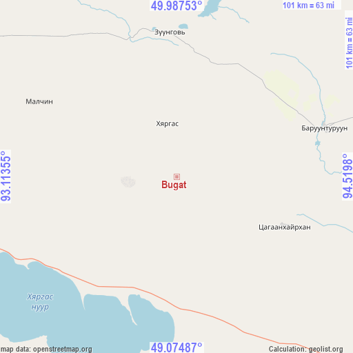
Bugat GPS coordinates[2]
49° 31' 59.988" North, 93° 49' 0.012" East
| Map corner | latitude | longitude |
|---|---|---|
| Upper-left | 49.98753°, | 93.11355° |
| Center: | 49.53333°, | 93.81667° |
| Lower-right: | 49.07487°, | 94.5198° |
| Map W x H: | 101.5×101.5 km | = 63.1×63.1mi |
| max Lat: | 51.50725° ⇑12% North |
| Bugat: | 49.53333° |
| min Lat: | ⇓88% South 42.84199° |
| min Long | Bugat | max Long |
| 89.14358° | 93.81667° | 118.51014° |
| W 12.9%⇐ | ⇒87.1% E |
Elevation
Elevation of Bugat is 1914 m = 6280 ft, and this is 497.5 m = 1632 ft above average elevation for this country.
| Max E: |
2800 m = 9186 ft | 13.8% |
| Bugat | 1914 m 6280 ft | |
| Avg. | 1416.5 m = 4647 ft | |
Min E: |
619 m = 2031 ft | 86.2% |
See also: Mongolia elevation on elevation.city.
Geographical zone
Bugat is located in North temperate zone (between Tropic of Cancer and the Arctic Circle). Distance of this North polar circle is 1893.6 km =1176.6 mi to North.| Distance of | km | miles | from Bugat |
|---|---|---|---|
| North Pole | 4499.5 | 2795.9 | to North |
| Arctic Circle | 1893.6 | 1176.6 | to North |
| Tropic Cancer | 2901.7 | 1803 | to South |
| Equator | 5507.6 | 3422.3 | to South |


Nearby cities:
15 places around Bugat: (largest is in red/bold)
• Baruunturuun
44.6 km =27.7 mi,  71°
71°
• Dzel
41.6 km =25.8 mi,  356°
356°
• Dzür
143.1 km =88.9 mi,  84°
84°
• Dzüünhövöö
156.6 km =97.3 mi,  319°
319°
• Har-Us
140.8 km =87.5 mi,  246°
246°
• Harhiraa
140.3 km =87.2 mi,  281°
281°
• Hungiy
118.3 km =73.5 mi,  162°
162°
• Jargalant
120.6 km =74.9 mi,  102°
102°
• Naranbulag
92.2 km =57.3 mi,  258°
258°
• Sharbulag
95.2 km =59.2 mi,  213°
213°
• Tooromt
105.1 km =65.3 mi,  350°
350°
• Tsagaanhayrhan
33.6 km =20.9 mi,  116°
116°
• Tsalgar
44.6 km =27.7 mi,  297°
297°
• Tsetserleg
80.8 km =50.2 mi,  111°
111°
• Ulaangom
135.2 km =84 mi,  291°
291°
Sources, notices
• [Note1] Compared only with cities in Mongolia existing in our database
• [Src1] Map data: © OpenStreetMap contributors (CC-BY-SA)
• [Src2] Other city data from geonames.org with taken over terms of usage.
• [Src3] Geographical zone / Annual Mean Temperature by Robert A. Rohde @ Wikipedia
