Har-Us geodata
Har-Us (Uvs) is a seat of a second-order administrative division; located in Mongolia in Asia/Hovd (GMT+7) time zone. In our database, there are 33 cities with bigger population. Compared to other cities in Mongolia, 77.3% of cities are located further ↓South; 92% of cities are located further →East and 68.1% of cities have lower elevation than Har-Us. Note1


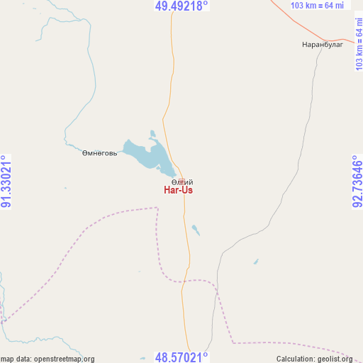
Har-Us GPS coordinates[2]
49° 1' 59.988" North, 92° 1' 59.988" East
| Map corner | latitude | longitude |
|---|---|---|
| Upper-left | 49.49218°, | 91.33021° |
| Center: | 49.03333°, | 92.03333° |
| Lower-right: | 48.57021°, | 92.73646° |
| Map W x H: | 102.5×102.5 km | = 63.7×63.7mi |
| max Lat: | 51.50725° ⇑22.7% North |
| Har-Us: | 49.03333° |
| min Lat: | ⇓77.3% South 42.84199° |
| min Long | Har-Us | max Long |
| 89.14358° | 92.03333° | 118.51014° |
| W 8%⇐ | ⇒92% E |
Elevation
Elevation of Har-Us is 1581 m = 5187 ft, and this is 164.5 m = 540 ft above average elevation for this country.
| Max E: |
2800 m = 9186 ft | 31.9% |
| Har-Us | 1581 m 5187 ft | |
| Avg. | 1416.5 m = 4647 ft | |
Min E: |
619 m = 2031 ft | 68.1% |
See also: Mongolia elevation on elevation.city.
Geographical zone
Har-Us is located in North temperate zone (between Tropic of Cancer and the Arctic Circle). Distance of this North polar circle is 1949.2 km =1211.2 mi to North.| Distance of | km | miles | from Har-Us |
|---|---|---|---|
| North Pole | 4555.1 | 2830.4 | to North |
| Arctic Circle | 1949.2 | 1211.2 | to North |
| Tropic Cancer | 2846.1 | 1768.5 | to South |
| Equator | 5452 | 3387.7 | to South |


Nearby cities:
15 places around Har-Us: (largest is in red/bold)
• Bayanhoshuu
89.4 km =55.6 mi,  185°
185°
• Bugat
140.8 km =87.5 mi,  66°
66°
• Buyant
108.7 km =67.5 mi, 188°
• Har-Us
75.3 km =46.8 mi,  215°
215°
• Harhiraa
83.4 km =51.8 mi,  353°
353°
• Havtsal
121.5 km =75.5 mi, 347°
• Höhtolgoy
86.2 km =53.6 mi,  288°
288°
• Khovd
117.9 km =73.3 mi, 194°
• Namir
24.4 km =15.2 mi, 289°
• Naranbulag
53.6 km =33.3 mi,  46°
46°
• Sharbulag
81.6 km =50.7 mi,  107°
107°
• Tsagaantüngi
115.4 km =71.7 mi,  270°
270°
• Tsalgar
117.2 km =72.8 mi, 49°
• Ulaangom
105.4 km =65.5 mi,  1°
1°
• Urdgol
141 km =87.6 mi,  161°
161°
Sources, notices
• [Note1] Compared only with cities in Mongolia existing in our database
• [Src1] Map data: © OpenStreetMap contributors (CC-BY-SA)
• [Src2] Other city data from geonames.org with taken over terms of usage.
• [Src3] Geographical zone / Annual Mean Temperature by Robert A. Rohde @ Wikipedia
