Gżira geodata
Gżira (Il-Gżira) is a seat of a first-order administrative division; located in Malta in Europe/Malta (GMT+2) time zone. With population of 7,513 people, there are 19 cities with bigger population in this country. Compared to other cities in Malta, 60.6% of cities are located further ↓South; 66.2% of cities are located further ←West and 84.5% of cities have higher elevation than Gżira. Note1


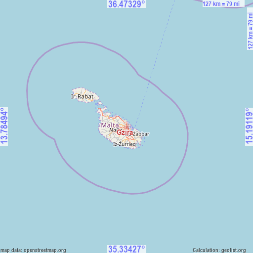
Gżira GPS coordinates[2]
35° 54' 20.988" North, 14° 29' 17.016" East
| Map corner | latitude | longitude |
|---|---|---|
| Upper-left | 36.47329°, | 13.78494° |
| Center: | 35.90583°, | 14.48806° |
| Lower-right: | 35.33427°, | 15.19119° |
| Map W x H: | 126.6×126.6 km | = 78.7×78.7mi |
| max Lat: | 36.07222° ⇑39.4% North |
| Gżira: | 35.90583° |
| min Lat: | ⇓60.6% South 35.82583° |
| min Long | Gżira | max Long |
| 14.20361° | 14.48806° | 14.56701° |
| W 66.2%⇐ | ⇒33.8% E |
Elevation
Elevation of Gżira is 31 m = 102 ft, and this is 47.1 m = 155 ft below average elevation for this country.
| Max E: |
231 m = 758 ft | 84.5% |
| Avg. | 78.1 m = 256 ft | |
| Gżira | 31 m = 102 ft | |
Min E: |
5 m = 16 ft | 15.5% |
See also: Malta elevation on elevation.city.
Geographical zone
Gżira is located in North temperate zone (between Tropic of Cancer and the Arctic Circle). Distance of this Northern Tropic circle is 1386.4 km =861.5 mi to South.| Distance of | km | miles | from Gżira |
|---|---|---|---|
| North Pole | 6014.7 | 3737.4 | to North |
| Arctic Circle | 3408.8 | 2118.1 | to North |
| Tropic Cancer | 1386.4 | 861.5 | to South |
| Equator | 3992.4 | 2480.8 | to South |


Nearby cities:
15 places around Gżira: (largest is in red/bold)
• Birkirkara
2.6 km =1.6 mi,  248°
248°
• Floriana
2.1 km =1.3 mi,  121°
121°
• Imsida
1.6 km =1 mi,  197°
197°
• Marsa
3 km =1.9 mi,  167°
167°
• Pembroke
2.9 km =1.8 mi,  339°
339°
• Pietà
1.4 km =0.9 mi,  153°
153°
• Saint John
1.1 km =0.7 mi,  268°
268°
• San Ġiljan
1.4 km =0.9 mi,  6°
6°
• Santa Venera
2.1 km =1.3 mi,  216°
216°
• Sliema
1.5 km =0.9 mi,  59°
59°
• Sprachcaffe
2.3 km =1.4 mi, 337°
• Swieqi
2 km =1.2 mi, 338°
• Ta’ Xbiex
0.9 km =0.6 mi,  142°
142°
• Valletta
2.5 km =1.6 mi,  105°
105°
• Ħamrun
2.4 km =1.5 mi,  187°
187°
Sources, notices
• [Note1] Compared only with cities in Malta existing in our database
• [Src1] Map data: © OpenStreetMap contributors (CC-BY-SA)
• [Src2] Other city data from geonames.org with taken over terms of usage.
• [Src3] Geographical zone / Annual Mean Temperature by Robert A. Rohde @ Wikipedia
