Saint John geodata
Saint John is a seat of a first-order administrative division; located in Malta in Europe/Malta (GMT+2) time zone. With population of 12,346 people, there are 5 cities with bigger population in this country. Compared to other cities in Malta, 59.2% of cities are located further ↓South; 54.9% of cities are located further ←West and 52.1% of cities have higher elevation than Saint John. Note1


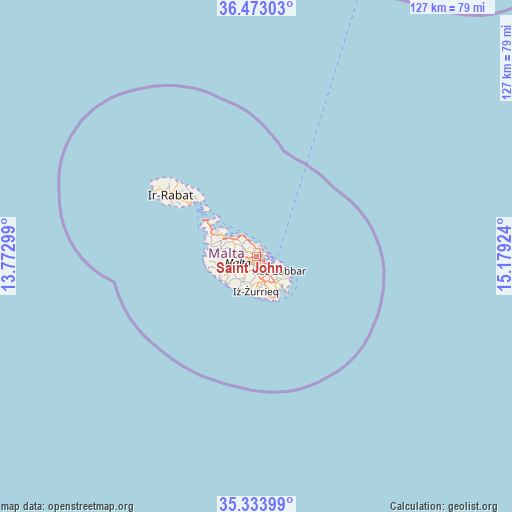
Saint John GPS coordinates[2]
35° 54' 20.016" North, 14° 28' 33.996" East
| Map corner | latitude | longitude |
|---|---|---|
| Upper-left | 36.47303°, | 13.77299° |
| Center: | 35.90556°, | 14.47611° |
| Lower-right: | 35.33399°, | 15.17924° |
| Map W x H: | 126.6×126.6 km | = 78.7×78.7mi |
| max Lat: | 36.07222° ⇑40.8% North |
| Saint John: | 35.90556° |
| min Lat: | ⇓59.2% South 35.82583° |
| min Long | Saint John | max Long |
| 14.20361° | 14.47611° | 14.56701° |
| W 54.9%⇐ | ⇒45.1% E |
Elevation
Elevation of Saint John is 67 m = 220 ft, and this is 11.1 m = 36 ft below average elevation for this country.
| Max E: |
231 m = 758 ft | 52.1% |
| Avg. | 78.1 m = 256 ft | |
| Saint John | 67 m = 220 ft | |
Min E: |
5 m = 16 ft | 47.9% |
See also: Malta elevation on elevation.city.
Geographical zone
Saint John is located in North temperate zone (between Tropic of Cancer and the Arctic Circle). Distance of this Northern Tropic circle is 1386.4 km =861.5 mi to South.| Distance of | km | miles | from Saint John |
|---|---|---|---|
| North Pole | 6014.7 | 3737.4 | to North |
| Arctic Circle | 3408.9 | 2118.2 | to North |
| Tropic Cancer | 1386.4 | 861.5 | to South |
| Equator | 3992.3 | 2480.7 | to South |


Nearby cities:
15 places around Saint John: (largest is in red/bold)
• Balzan
2 km =1.2 mi,  252°
252°
• Birkirkara
1.6 km =1 mi,  235°
235°
• Gżira
1.1 km =0.7 mi,  88°
88°
• Imsida
1.6 km =1 mi,  157°
157°
• L-Iklin
2 km =1.2 mi,  265°
265°
• Lija
2.7 km =1.7 mi,  258°
258°
• Pembroke
2.8 km =1.7 mi,  0°
0°
• Pietà
2.1 km =1.3 mi,  125°
125°
• San Ġiljan
1.9 km =1.2 mi,  40°
40°
• Santa Venera
1.6 km =1 mi,  186°
186°
• Sliema
2.5 km =1.6 mi,  71°
71°
• Sprachcaffe
2.2 km =1.4 mi, 4°
• Swieqi
1.9 km =1.2 mi,  10°
10°
• Ta’ Xbiex
1.8 km =1.1 mi,  113°
113°
• Ħamrun
2.4 km =1.5 mi, 162°
Sources, notices
• [Note1] Compared only with cities in Malta existing in our database
• [Src1] Map data: © OpenStreetMap contributors (CC-BY-SA)
• [Src2] Other city data from geonames.org with taken over terms of usage.
• [Src3] Geographical zone / Annual Mean Temperature by Robert A. Rohde @ Wikipedia
