Pembroke geodata
Pembroke is a seat of a first-order administrative division; located in Malta in Europe/Malta (GMT+2) time zone. With population of 3,038 people, there are 41 cities with bigger population in this country. Compared to other cities in Malta, 73.2% of cities are located further ↓South; 56.3% of cities are located further ←West and 74.6% of cities have higher elevation than Pembroke. Note1


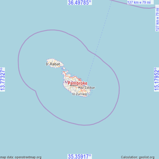
Pembroke GPS coordinates[2]
35° 55' 50.016" North, 14° 28' 35.004" East
| Map corner | latitude | longitude |
|---|---|---|
| Upper-left | 36.49785°, | 13.77327° |
| Center: | 35.93056°, | 14.47639° |
| Lower-right: | 35.35917°, | 15.17952° |
| Map W x H: | 126.6×126.6 km | = 78.7×78.7mi |
| max Lat: | 36.07222° ⇑26.8% North |
| Pembroke: | 35.93056° |
| min Lat: | ⇓73.2% South 35.82583° |
| min Long | Pembroke | max Long |
| 14.20361° | 14.47639° | 14.56701° |
| W 56.3%⇐ | ⇒43.7% E |
Elevation
Elevation of Pembroke is 41 m = 135 ft, and this is 37.1 m = 122 ft below average elevation for this country.
| Max E: |
231 m = 758 ft | 74.6% |
| Avg. | 78.1 m = 256 ft | |
| Pembroke | 41 m = 135 ft | |
Min E: |
5 m = 16 ft | 25.4% |
See also: Malta elevation on elevation.city.
Geographical zone
Pembroke is located in North temperate zone (between Tropic of Cancer and the Arctic Circle). Distance of this Northern Tropic circle is 1389.2 km =863.2 mi to South.| Distance of | km | miles | from Pembroke |
|---|---|---|---|
| North Pole | 6012 | 3735.7 | to North |
| Arctic Circle | 3406.1 | 2116.5 | to North |
| Tropic Cancer | 1389.2 | 863.2 | to South |
| Equator | 3995.1 | 2482.4 | to South |


Nearby cities:
15 places around Pembroke: (largest is in red/bold)
• Balzan
3.9 km =2.4 mi,  209°
209°
• Birkirkara
4 km =2.5 mi,  200°
200°
• Gżira
2.9 km =1.8 mi,  159°
159°
• Hal Gharghur
2.4 km =1.5 mi,  252°
252°
• Imsida
4.3 km =2.7 mi,  172°
172°
• L-Iklin
3.6 km =2.2 mi, 214°
• Lija
4.3 km =2.7 mi,  219°
219°
• Naxxar
3.5 km =2.2 mi,  237°
237°
• Pietà
4.3 km =2.7 mi, 157°
• Saint John
2.8 km =1.7 mi,  180°
180°
• San Ġiljan
1.8 km =1.1 mi,  138°
138°
• Sliema
3.1 km =1.9 mi,  131°
131°
• Sprachcaffe
0.6 km =0.4 mi, 165°
• Swieqi
1 km =0.6 mi, 160°
• Ta’ Xbiex
3.9 km =2.4 mi, 155°
Sources, notices
• [Note1] Compared only with cities in Malta existing in our database
• [Src1] Map data: © OpenStreetMap contributors (CC-BY-SA)
• [Src2] Other city data from geonames.org with taken over terms of usage.
• [Src3] Geographical zone / Annual Mean Temperature by Robert A. Rohde @ Wikipedia
