Mellieħa geodata
Mellieħa (Il-Mellieħa) is a seat of a first-order administrative division; located in Malta in Europe/Malta (GMT+2) time zone. With population of 5,976 people, there are 27 cities with bigger population in this country. Compared to other cities in Malta, 76.1% of cities are located further ↓South; 76.1% of cities are located further →East and 81.7% of cities have lower elevation than Mellieħa. Note1


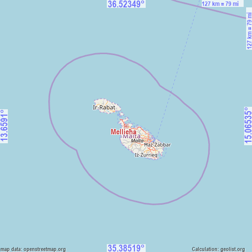
Mellieħa GPS coordinates[2]
35° 57' 23.004" North, 14° 21' 43.992" East
| Map corner | latitude | longitude |
|---|---|---|
| Upper-left | 36.52349°, | 13.6591° |
| Center: | 35.95639°, | 14.36222° |
| Lower-right: | 35.38519°, | 15.06535° |
| Map W x H: | 126.6×126.6 km | = 78.7×78.7mi |
| max Lat: | 36.07222° ⇑23.9% North |
| Mellieħa: | 35.95639° |
| min Lat: | ⇓76.1% South 35.82583° |
| min Long | Mellieħa | max Long |
| 14.20361° | 14.36222° | 14.56701° |
| W 23.9%⇐ | ⇒76.1% E |
Elevation
Elevation of Mellieħa is 121 m = 397 ft, and this is 42.9 m = 141 ft above average elevation for this country.
| Max E: |
231 m = 758 ft | 18.3% |
| Mellieħa | 121 m 397 ft | |
| Avg. | 78.1 m = 256 ft | |
Min E: |
5 m = 16 ft | 81.7% |
See also: Malta elevation on elevation.city.
Geographical zone
Mellieħa is located in North temperate zone (between Tropic of Cancer and the Arctic Circle). Distance of this Northern Tropic circle is 1392.1 km =865 mi to South.| Distance of | km | miles | from Mellieħa |
|---|---|---|---|
| North Pole | 6009.1 | 3733.9 | to North |
| Arctic Circle | 3403.2 | 2114.6 | to North |
| Tropic Cancer | 1392.1 | 865 | to South |
| Equator | 3998 | 2484.2 | to South |


Nearby cities:
15 places around Mellieħa: (largest is in red/bold)
• Attard
10.4 km =6.5 mi,  135°
135°
• Balzan
10.4 km =6.5 mi,  126°
126°
• Għajnsielem
10.4 km =6.5 mi,  318°
318°
• Hal Gharghur
8.8 km =5.5 mi,  114°
114°
• Imdina
8.5 km =5.3 mi,  154°
154°
• Imtarfa
7.8 km =4.8 mi, 154°
• Imġarr
4 km =2.5 mi,  174°
174°
• L-Iklin
10.1 km =6.3 mi, 125°
• Lija
9.8 km =6.1 mi, 129°
• Mosta
7.8 km =4.8 mi, 132°
• Mġarr
9.8 km =6.1 mi, 321°
• Naxxar
8.7 km =5.4 mi,  122°
122°
• Qala
10.1 km =6.3 mi,  331°
331°
• Rabat
9 km =5.6 mi,  158°
158°
• San Pawl il-Baħar
4.8 km =3 mi,  97°
97°
Sources, notices
• [Note1] Compared only with cities in Malta existing in our database
• [Src1] Map data: © OpenStreetMap contributors (CC-BY-SA)
• [Src2] Other city data from geonames.org with taken over terms of usage.
• [Src3] Geographical zone / Annual Mean Temperature by Robert A. Rohde @ Wikipedia
