Luqa geodata
Luqa is a seat of a first-order administrative division; located in Malta in Europe/Malta (GMT+2) time zone. With population of 5,053 people, there are 30 cities with bigger population in this country. Compared to other cities in Malta, 84.5% of cities are located further ↑North; 67.6% of cities are located further ←West and 56.3% of cities have lower elevation than Luqa. Note1


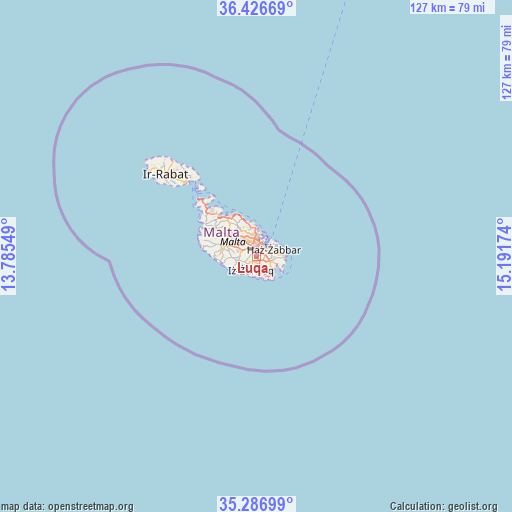
Luqa GPS coordinates[2]
35° 51' 32.004" North, 14° 29' 18.996" East
| Map corner | latitude | longitude |
|---|---|---|
| Upper-left | 36.42669°, | 13.78549° |
| Center: | 35.85889°, | 14.48861° |
| Lower-right: | 35.28699°, | 15.19174° |
| Map W x H: | 126.7×126.7 km | = 78.7×78.7mi |
| max Lat: | 36.07222° ⇑84.5% North |
| Luqa: | 35.85889° |
| min Lat: | ⇓15.5% South 35.82583° |
| min Long | Luqa | max Long |
| 14.20361° | 14.48861° | 14.56701° |
| W 67.6%⇐ | ⇒32.4% E |
Elevation
Elevation of Luqa is 79 m = 259 ft, and this is 0.90000000000001 m = 3 ft above average elevation for this country.
| Max E: |
231 m = 758 ft | 43.7% |
| Luqa | 79 m 259 ft | |
| Avg. | 78.1 m = 256 ft | |
Min E: |
5 m = 16 ft | 56.3% |
See also: Malta elevation on elevation.city.
Geographical zone
Luqa is located in North temperate zone (between Tropic of Cancer and the Arctic Circle). Distance of this Northern Tropic circle is 1381.2 km =858.2 mi to South.| Distance of | km | miles | from Luqa |
|---|---|---|---|
| North Pole | 6019.9 | 3740.6 | to North |
| Arctic Circle | 3414 | 2121.4 | to North |
| Tropic Cancer | 1381.2 | 858.2 | to South |
| Equator | 3987.1 | 2477.5 | to South |


Nearby cities:
15 places around Luqa: (largest is in red/bold)
• Fgura
2.6 km =1.6 mi,  60°
60°
• Gudja
1.7 km =1.1 mi,  129°
129°
• Għaxaq
2.8 km =1.7 mi,  113°
113°
• Kirkop
1.9 km =1.2 mi,  189°
189°
• Marsa
2.3 km =1.4 mi,  14°
14°
• Mqabba
2.2 km =1.4 mi,  235°
235°
• Paola
1.8 km =1.1 mi,  30°
30°
• Qormi
2.4 km =1.5 mi,  321°
321°
• Qrendi
3.8 km =2.4 mi,  225°
225°
• Safi
2.9 km =1.8 mi, 186°
• Santa Luċija
1.8 km =1.1 mi,  75°
75°
• Santa Venera
3.8 km =2.4 mi,  339°
339°
• Tarxien
2.5 km =1.6 mi,  72°
72°
• Ħamrun
2.9 km =1.8 mi,  352°
352°
• Żurrieq
3.4 km =2.1 mi,  202°
202°
Sources, notices
• [Note1] Compared only with cities in Malta existing in our database
• [Src1] Map data: © OpenStreetMap contributors (CC-BY-SA)
• [Src2] Other city data from geonames.org with taken over terms of usage.
• [Src3] Geographical zone / Annual Mean Temperature by Robert A. Rohde @ Wikipedia
