Pietà geodata
Pietà (Tal-Pietà) is a seat of a first-order administrative division; located in Malta in Europe/Malta (GMT+2) time zone. With population of 3,846 people, there are 33 cities with bigger population in this country. Compared to other cities in Malta, 52.1% of cities are located further ↑North; 71.8% of cities are located further ←West and 87.3% of cities have higher elevation than Pietà. Note1


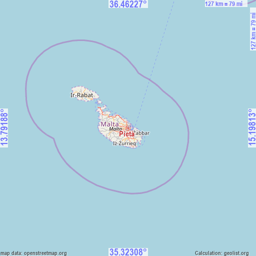
Pietà GPS coordinates[2]
35° 53' 40.992" North, 14° 29' 42" East
| Map corner | latitude | longitude |
|---|---|---|
| Upper-left | 36.46227°, | 13.79188° |
| Center: | 35.89472°, | 14.495° |
| Lower-right: | 35.32308°, | 15.19813° |
| Map W x H: | 126.7×126.7 km | = 78.7×78.7mi |
| max Lat: | 36.07222° ⇑52.1% North |
| Pietà: | 35.89472° |
| min Lat: | ⇓47.9% South 35.82583° |
| min Long | Pietà | max Long |
| 14.20361° | 14.495° | 14.56701° |
| W 71.8%⇐ | ⇒28.2% E |
Elevation
Elevation of Pietà is 30 m = 98 ft, and this is 48.1 m = 158 ft below average elevation for this country.
| Max E: |
231 m = 758 ft | 87.3% |
| Avg. | 78.1 m = 256 ft | |
| Pietà | 30 m = 98 ft | |
Min E: |
5 m = 16 ft | 12.7% |
See also: Malta elevation on elevation.city.
Geographical zone
Pietà is located in North temperate zone (between Tropic of Cancer and the Arctic Circle). Distance of this Northern Tropic circle is 1385.2 km =860.7 mi to South.| Distance of | km | miles | from Pietà |
|---|---|---|---|
| North Pole | 6015.9 | 3738.1 | to North |
| Arctic Circle | 3410.1 | 2118.9 | to North |
| Tropic Cancer | 1385.2 | 860.7 | to South |
| Equator | 3991.1 | 2480 | to South |


Nearby cities:
15 places around Pietà: (largest is in red/bold)
• Floriana
1.2 km =0.7 mi,  84°
84°
• Gżira
1.4 km =0.9 mi,  333°
333°
• Imsida
1.1 km =0.7 mi,  257°
257°
• Marsa
1.7 km =1.1 mi,  179°
179°
• Paola
2.4 km =1.5 mi,  171°
171°
• Qormi
2.9 km =1.8 mi,  224°
224°
• Saint John
2.1 km =1.3 mi,  305°
305°
• San Ġiljan
2.7 km =1.7 mi,  349°
349°
• Santa Venera
1.9 km =1.2 mi, 257°
• Senglea
2.1 km =1.3 mi,  112°
112°
• Sliema
2.1 km =1.3 mi,  17°
17°
• Ta’ Xbiex
0.5 km =0.3 mi, 354°
• Valletta
1.9 km =1.2 mi,  72°
72°
• Vittoriosa
2.1 km =1.3 mi,  97°
97°
• Ħamrun
1.5 km =0.9 mi, 220°
Sources, notices
• [Note1] Compared only with cities in Malta existing in our database
• [Src1] Map data: © OpenStreetMap contributors (CC-BY-SA)
• [Src2] Other city data from geonames.org with taken over terms of usage.
• [Src3] Geographical zone / Annual Mean Temperature by Robert A. Rohde @ Wikipedia
