El Huayal geodata
El Huayal (San Luis Potosí) is a populated place; located in Mexico in America/Mexico_City (GMT-6) time zone. With population of 878 people, there are 9946 cities with bigger population in this country. Compared to other cities in Mexico, 81.3% of cities are located further ↓South; 56.1% of cities are located further ←West and 79.7% of cities have higher elevation than El Huayal. Note1


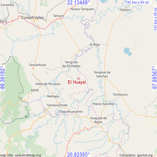
El Huayal GPS coordinates[2]
21° 28' 54.084" North, 98° 35' 55.644" West
| Map corner | latitude | longitude |
|---|---|---|
| Upper-left | 22.13449°, | -99.30192° |
| Center: | 21.48169°, | -98.59879° |
| Lower-right: | 20.82595°, | -97.89567° |
| Map W x H: | 145.5×145.5 km | = 90.4×90.4mi |
| max Lat: | 32.7° ⇑18.7% North |
| El Huayal: | 21.48169° |
| min Lat: | ⇓81.3% South 14.53588° |
| min Long | El Huayal | max Long |
| -117.105° | -98.59879° | -86.73105° |
| W 56.1%⇐ | ⇒43.9% E |
Elevation
Elevation of El Huayal is 99 m = 325 ft, and this is 1154.7 m = 3788 ft below average elevation for this country.
| Max E: |
3497 m = 11473 ft | 79.7% |
| Avg. | 1253.7 m = 4113 ft | |
| El Huayal | 99 m = 325 ft | |
Min E: |
-1 m = -3 ft | 20.3% |
See also: Mexico elevation on elevation.city.
Geographical zone
El Huayal is located in North Torrid zone (between Equator and Tropic of Cancer). Distance of this Northern Tropic circle is 217.4 km =135.1 mi to North.| Distance of | km | miles | from El Huayal |
|---|---|---|---|
| North Pole | 7618.5 | 4733.9 | to North |
| Arctic Circle | 5012.6 | 3114.7 | to North |
| Tropic Cancer | 217.4 | 135.1 | to North |
| Equator | 2388.5 | 1484.1 | to South |


Nearby cities:
15 places around El Huayal: (largest is in red/bold)
• Chiconamel
17.7 km =11 mi,  224°
224°
• Chililillo
18.5 km =11.5 mi,  239°
239°
• Corozal
8.5 km =5.3 mi,  32°
32°
• El Aguacate Terrero
19.2 km =11.9 mi,  111°
111°
• El Hule Nuevo
17.7 km =11 mi,  14°
14°
• Escoatitla
19.6 km =12.2 mi,  213°
213°
• La Soledad
16.4 km =10.2 mi,  232°
232°
• Las Piedras
16.7 km =10.4 mi,  143°
143°
• Macuilocatl
17.7 km =11 mi, 233°
• Manchoc
18.1 km =11.2 mi, 212°
• San Martín Chalchicuautla
13.8 km =8.6 mi, 205°
• Tampacán
16.1 km =10 mi, 236°
• Tanquián de Escobedo
15.3 km =9.5 mi,  334°
334°
• Tenextitla Dos
16.7 km =10.4 mi, 222°
• Xochicuatla
19.6 km =12.2 mi, 225°
Sources, notices
• [Note1] Compared only with cities in Mexico existing in our database
• [Src1] Map data: © OpenStreetMap contributors (CC-BY-SA)
• [Src2] Other city data from geonames.org with taken over terms of usage.
• [Src3] Geographical zone / Annual Mean Temperature by Robert A. Rohde @ Wikipedia
