Las Piedras geodata
Las Piedras (Hidalgo) is a populated place; located in Mexico in America/Mexico_City (GMT-6) time zone. With population of 1,000 people, there are 8715 cities with bigger population in this country. Compared to other cities in Mexico, 80.5% of cities are located further ↓South; 57.2% of cities are located further ←West and 81.6% of cities have higher elevation than Las Piedras. Note1


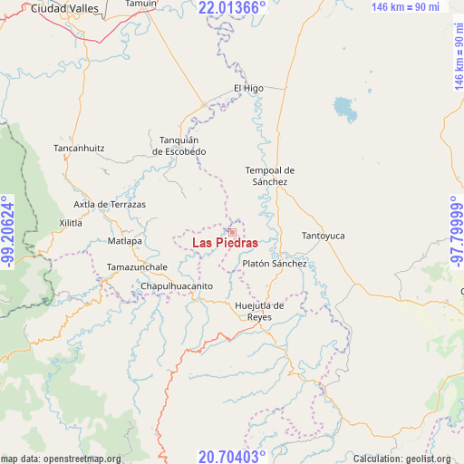
Las Piedras GPS coordinates[2]
21° 21' 37.116" North, 98° 30' 11.196" West
| Map corner | latitude | longitude |
|---|---|---|
| Upper-left | 22.01366°, | -99.20624° |
| Center: | 21.36031°, | -98.50311° |
| Lower-right: | 20.70403°, | -97.79999° |
| Map W x H: | 145.6×145.6 km | = 90.5×90.5mi |
| max Lat: | 32.7° ⇑19.5% North |
| Las Piedras: | 21.36031° |
| min Lat: | ⇓80.5% South 14.53588° |
| min Long | Las Piedras | max Long |
| -117.105° | -98.50311° | -86.73105° |
| W 57.2%⇐ | ⇒42.8% E |
Elevation
Elevation of Las Piedras is 75 m = 246 ft, and this is 1178.7 m = 3867 ft below average elevation for this country.
| Max E: |
3497 m = 11473 ft | 81.6% |
| Avg. | 1253.7 m = 4113 ft | |
| Las Piedras | 75 m = 246 ft | |
Min E: |
-1 m = -3 ft | 18.4% |
See also: Mexico elevation on elevation.city.
Geographical zone
Las Piedras is located in North Torrid zone (between Equator and Tropic of Cancer). Distance of this Northern Tropic circle is 230.9 km =143.5 mi to North.| Distance of | km | miles | from Las Piedras |
|---|---|---|---|
| North Pole | 7632 | 4742.3 | to North |
| Arctic Circle | 5026.1 | 3123.1 | to North |
| Tropic Cancer | 230.9 | 143.5 | to North |
| Equator | 2375 | 1475.8 | to South |


Nearby cities:
15 places around Las Piedras: (largest is in red/bold)
• Chiconamel
15.1 km =9.4 mi,  162°
162°
• Cochiscuatitla
17.9 km =11.1 mi,  196°
196°
• Cruztitla
13.3 km =8.3 mi,  185°
185°
• El Aguacate Terrero
10.1 km =6.3 mi,  51°
51°
• El Huayal
16.7 km =10.4 mi,  323°
323°
• El Remanso
17 km =10.6 mi,  112°
112°
• Las Chacas
16.8 km =10.4 mi, 187°
• Las Mesas San Gabriel (Las Mesas)
14.3 km =8.9 mi,  75°
75°
• Piedra Hincada
11.2 km =7 mi,  209°
209°
• Platón Sánchez
16.6 km =10.3 mi,  126°
126°
• Potejamel
14.9 km =9.3 mi,  220°
220°
• San Martín Chalchicuautla
16 km =9.9 mi,  274°
274°
• San Pedro Coyutla
16.9 km =10.5 mi,  153°
153°
• Zohuala
14.4 km =8.9 mi,  172°
172°
• Ámaxac
16.3 km =10.1 mi, 170°
Sources, notices
• [Note1] Compared only with cities in Mexico existing in our database
• [Src1] Map data: © OpenStreetMap contributors (CC-BY-SA)
• [Src2] Other city data from geonames.org with taken over terms of usage.
• [Src3] Geographical zone / Annual Mean Temperature by Robert A. Rohde @ Wikipedia
