La Pila geodata
La Pila (San Luis Potosí) is a populated place; located in Mexico in America/Mexico_City (GMT-6) time zone. With population of 598 people, there are 14373 cities with bigger population in this country. Compared to other cities in Mexico, 83.3% of cities are located further ↓South; 50.9% of cities are located further →East and 79.3% of cities have higher elevation than La Pila. Note1


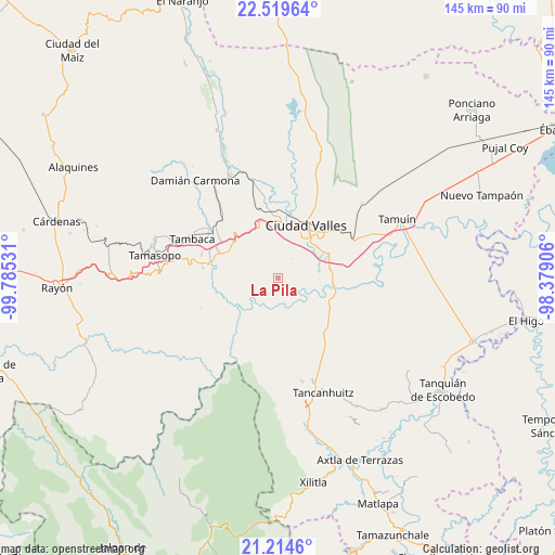
La Pila GPS coordinates[2]
21° 52' 6.996" North, 99° 4' 55.848" West
| Map corner | latitude | longitude |
|---|---|---|
| Upper-left | 22.51964°, | -99.78531° |
| Center: | 21.86861°, | -99.08218° |
| Lower-right: | 21.2146°, | -98.37906° |
| Map W x H: | 145.1×145.1 km | = 90.2×90.2mi |
| max Lat: | 32.7° ⇑16.7% North |
| La Pila: | 21.86861° |
| min Lat: | ⇓83.3% South 14.53588° |
| min Long | La Pila | max Long |
| -117.105° | -99.08218° | -86.73105° |
| W 49.1%⇐ | ⇒50.9% E |
Elevation
Elevation of La Pila is 105 m = 344 ft, and this is 1148.7 m = 3769 ft below average elevation for this country.
| Max E: |
3497 m = 11473 ft | 79.3% |
| Avg. | 1253.7 m = 4113 ft | |
| La Pila | 105 m = 344 ft | |
Min E: |
-1 m = -3 ft | 20.7% |
See also: Mexico elevation on elevation.city.
Geographical zone
La Pila is located in North Torrid zone (between Equator and Tropic of Cancer). Distance of this Northern Tropic circle is 174.4 km =108.4 mi to North.| Distance of | km | miles | from La Pila |
|---|---|---|---|
| North Pole | 7575.5 | 4707.2 | to North |
| Arctic Circle | 4969.6 | 3088 | to North |
| Tropic Cancer | 174.4 | 108.4 | to North |
| Equator | 2431.6 | 1510.9 | to South |


Nearby cities:
15 places around La Pila: (largest is in red/bold)
• Ciudad Valles
16 km =9.9 mi,  27°
27°
• El Jabalí
16.1 km =10 mi,  279°
279°
• El Naranjito
10 km =6.2 mi,  258°
258°
• El Ojite
11.8 km =7.3 mi,  342°
342°
• La Calera
13.9 km =8.6 mi,  78°
78°
• La Lima
6.9 km =4.3 mi, 341°
• La Subida
4.4 km =2.7 mi, 336°
• Los Otates
15.9 km =9.9 mi,  328°
328°
• Ojo de Agua
10.8 km =6.7 mi, 342°
• Rancho Nuevo
1.1 km =0.7 mi,  321°
321°
• Rancho Nuevo
19.5 km =12.1 mi,  166°
166°
• San Antonio Huichimal
8.2 km =5.1 mi, 342°
• Tanchachín
8 km =5 mi,  238°
238°
• Tantóbal
17.4 km =10.8 mi,  122°
122°
• Zocohuite
17 km =10.6 mi, 340°
Sources, notices
• [Note1] Compared only with cities in Mexico existing in our database
• [Src1] Map data: © OpenStreetMap contributors (CC-BY-SA)
• [Src2] Other city data from geonames.org with taken over terms of usage.
• [Src3] Geographical zone / Annual Mean Temperature by Robert A. Rohde @ Wikipedia
