Rancho Nuevo geodata
Rancho Nuevo (San Luis Potosí) is a populated place; located in Mexico in America/Mexico_City (GMT-6) time zone. With population of 603 people, there are 14266 cities with bigger population in this country. Compared to other cities in Mexico, 83.4% of cities are located further ↓South; 51% of cities are located further →East and 78.7% of cities have higher elevation than Rancho Nuevo. Note1


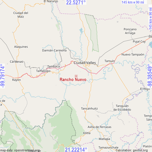
Rancho Nuevo GPS coordinates[2]
21° 52' 33.996" North, 99° 5' 18.996" West
| Map corner | latitude | longitude |
|---|---|---|
| Upper-left | 22.5271°, | -99.79174° |
| Center: | 21.87611°, | -99.08861° |
| Lower-right: | 21.22214°, | -98.38549° |
| Map W x H: | 145.1×145.1 km | = 90.2×90.2mi |
| max Lat: | 32.7° ⇑16.6% North |
| Rancho Nuevo: | 21.87611° |
| min Lat: | ⇓83.4% South 14.53588° |
| min Long | Rancho Nuevo | max Long |
| -117.105° | -99.08861° | -86.73105° |
| W 49%⇐ | ⇒51% E |
Elevation
Elevation of Rancho Nuevo is 117 m = 384 ft, and this is 1136.7 m = 3729 ft below average elevation for this country.
| Max E: |
3497 m = 11473 ft | 78.7% |
| Avg. | 1253.7 m = 4113 ft | |
| Rancho Nuevo | 117 m = 384 ft | |
Min E: |
-1 m = -3 ft | 21.3% |
See also: Mexico elevation on elevation.city.
Geographical zone
Rancho Nuevo is located in North Torrid zone (between Equator and Tropic of Cancer). Distance of this Northern Tropic circle is 173.5 km =107.8 mi to North.| Distance of | km | miles | from Rancho Nuevo |
|---|---|---|---|
| North Pole | 7574.7 | 4706.7 | to North |
| Arctic Circle | 4968.8 | 3087.5 | to North |
| Tropic Cancer | 173.5 | 107.8 | to North |
| Equator | 2432.4 | 1511.4 | to South |


Nearby cities:
15 places around Rancho Nuevo: (largest is in red/bold)
• Ciudad Valles
15.6 km =9.7 mi,  30°
30°
• Coyoles
18.8 km =11.7 mi,  351°
351°
• El Jabalí
15.3 km =9.5 mi,  276°
276°
• El Naranjito
9.6 km =6 mi,  252°
252°
• El Ojite
10.8 km =6.7 mi, 345°
• La Calera
14.4 km =8.9 mi,  82°
82°
• La Lima
5.9 km =3.7 mi, 345°
• La Pila
1.1 km =0.7 mi,  141°
141°
• La Subida
3.4 km =2.1 mi,  341°
341°
• Los Otates
14.8 km =9.2 mi,  329°
329°
• Ojo de Agua
9.9 km =6.2 mi, 344°
• San Antonio Huichimal
7.2 km =4.5 mi, 345°
• Tanchachín
8 km =5 mi,  230°
230°
• Tantóbal
18.4 km =11.4 mi,  123°
123°
• Zocohuite
16 km =9.9 mi, 342°
Sources, notices
• [Note1] Compared only with cities in Mexico existing in our database
• [Src1] Map data: © OpenStreetMap contributors (CC-BY-SA)
• [Src2] Other city data from geonames.org with taken over terms of usage.
• [Src3] Geographical zone / Annual Mean Temperature by Robert A. Rohde @ Wikipedia
