Rancho Nuevo geodata
Rancho Nuevo (San Luis Potosí) is a populated place; located in Mexico in America/Mexico_City (GMT-6) time zone. With population of 895 people, there are 9743 cities with bigger population in this country. Compared to other cities in Mexico, 82.4% of cities are located further ↓South; 50.3% of cities are located further →East and 82.9% of cities have higher elevation than Rancho Nuevo. Note1


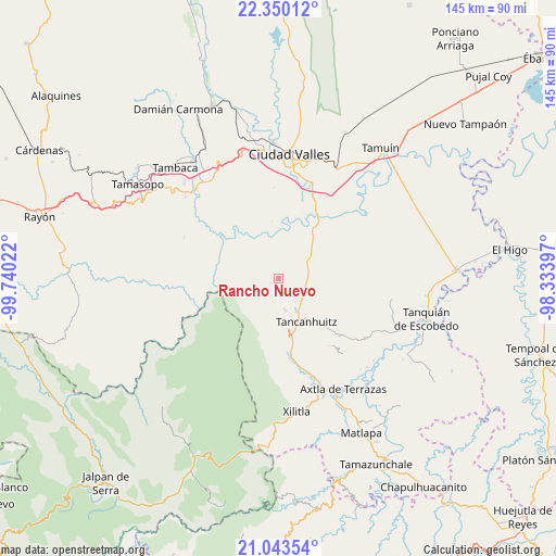
Rancho Nuevo GPS coordinates[2]
21° 41' 53.916" North, 99° 2' 13.524" West
| Map corner | latitude | longitude |
|---|---|---|
| Upper-left | 22.35012°, | -99.74022° |
| Center: | 21.69831°, | -99.03709° |
| Lower-right: | 21.04354°, | -98.33397° |
| Map W x H: | 145.3×145.3 km | = 90.3×90.3mi |
| max Lat: | 32.7° ⇑17.6% North |
| Rancho Nuevo: | 21.69831° |
| min Lat: | ⇓82.4% South 14.53588° |
| min Long | Rancho Nuevo | max Long |
| -117.105° | -99.03709° | -86.73105° |
| W 49.7%⇐ | ⇒50.3% E |
Elevation
Elevation of Rancho Nuevo is 61 m = 200 ft, and this is 1192.7 m = 3913 ft below average elevation for this country.
| Max E: |
3497 m = 11473 ft | 82.9% |
| Avg. | 1253.7 m = 4113 ft | |
| Rancho Nuevo | 61 m = 200 ft | |
Min E: |
-1 m = -3 ft | 17.1% |
See also: Mexico elevation on elevation.city.
Geographical zone
Rancho Nuevo is located in North Torrid zone (between Equator and Tropic of Cancer). Distance of this Northern Tropic circle is 193.3 km =120.1 mi to North.| Distance of | km | miles | from Rancho Nuevo |
|---|---|---|---|
| North Pole | 7594.4 | 4718.9 | to North |
| Arctic Circle | 4988.5 | 3099.7 | to North |
| Tropic Cancer | 193.3 | 120.1 | to North |
| Equator | 2412.6 | 1499.1 | to South |


Nearby cities:
15 places around Rancho Nuevo: (largest is in red/bold)
• Aquismón
8.7 km =5.4 mi,  168°
168°
• Ejido San José Xilatzén
11.6 km =7.2 mi,  103°
103°
• Lanim
10.3 km =6.4 mi,  161°
161°
• Las Armas
7.2 km =4.5 mi,  91°
91°
• Mantezulel
8.1 km =5 mi,  194°
194°
• Puhuitzé
4 km =2.5 mi,  231°
231°
• San José Pequetzén
11.1 km =6.9 mi,  133°
133°
• San Rafael Tamápatz
12.5 km =7.8 mi,  221°
221°
• Tamcuime
11.1 km =6.9 mi, 165°
• Tampate
7 km =4.3 mi, 170°
• Tampemoche
4.7 km =2.9 mi,  257°
257°
• Tancanhuitz
13.3 km =8.3 mi,  147°
147°
• Tanchanaco
3.6 km =2.2 mi,  195°
195°
• Tantóbal
13.8 km =8.6 mi,  46°
46°
• Tanute
5.1 km =3.2 mi,  180°
180°
Sources, notices
• [Note1] Compared only with cities in Mexico existing in our database
• [Src1] Map data: © OpenStreetMap contributors (CC-BY-SA)
• [Src2] Other city data from geonames.org with taken over terms of usage.
• [Src3] Geographical zone / Annual Mean Temperature by Robert A. Rohde @ Wikipedia
