La Lima geodata
La Lima (San Luis Potosí) is a populated place; located in Mexico in America/Mexico_City (GMT-6) time zone. With population of 1,579 people, there are 5470 cities with bigger population in this country. Compared to other cities in Mexico, 83.7% of cities are located further ↓South; 51.2% of cities are located further →East and 77.5% of cities have higher elevation than La Lima. Note1


La Lima GPS coordinates[2]
21° 55' 37.992" North, 99° 6' 10.008" West
| Map corner | latitude | longitude |
|---|---|---|
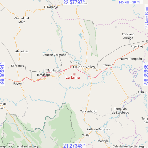
| Upper-left | 22.57797°, | -99.80591° |
| Center: | 21.92722°, | -99.10278° |
| Lower-right: | 21.27348°, | -98.39966° |
| Map W x H: | 145×145 km | = 90.1×90.1mi |
| max Lat: | 32.7° ⇑16.3% North |
| La Lima: | 21.92722° |
| min Lat: | ⇓83.7% South 14.53588° |
| min Long | La Lima | max Long |
| -117.105° | -99.10278° | -86.73105° |
| W 48.8%⇐ | ⇒51.2% E |
Elevation
Elevation of La Lima is 142 m = 466 ft, and this is 1111.7 m = 3647 ft below average elevation for this country.
| Max E: |
3497 m = 11473 ft | 77.5% |
| Avg. | 1253.7 m = 4113 ft | |
| La Lima | 142 m = 466 ft | |
Min E: |
-1 m = -3 ft | 22.5% |
See also: Mexico elevation on elevation.city.
Geographical zone
La Lima is located in North Torrid zone (between Equator and Tropic of Cancer). Distance of this Northern Tropic circle is 167.8 km =104.3 mi to North.| Distance of | km | miles | from La Lima |
|---|---|---|---|
| North Pole | 7569 | 4703.2 | to North |
| Arctic Circle | 4963.1 | 3083.9 | to North |
| Tropic Cancer | 167.8 | 104.3 | to North |
| Equator | 2438.1 | 1515 | to South |


Nearby cities:
15 places around La Lima: (largest is in red/bold)
• Ciudad Valles
12.2 km =7.6 mi,  50°
50°
• Coyoles
12.9 km =8 mi,  354°
354°
• El Jabalí
14.3 km =8.9 mi,  254°
254°
• El Naranjito
11.5 km =7.1 mi,  221°
221°
• El Ojite
4.9 km =3 mi,  344°
344°
• Estacion San Dieguito
15.3 km =9.5 mi,  306°
306°
• La Calera
16.2 km =10.1 mi,  103°
103°
• La Pila
6.9 km =4.3 mi,  161°
161°
• La Subida
2.5 km =1.6 mi,  170°
170°
• Los Otates
9.4 km =5.8 mi,  318°
318°
• Ojo de Agua
4 km =2.5 mi, 342°
• Rancho Nuevo
5.9 km =3.7 mi, 165°
• San Antonio Huichimal
1.4 km =0.9 mi, 344°
• Tanchachín
11.8 km =7.3 mi,  203°
203°
• Zocohuite
10.1 km =6.3 mi, 340°
Sources, notices
• [Note1] Compared only with cities in Mexico existing in our database
• [Src1] Map data: © OpenStreetMap contributors (CC-BY-SA)
• [Src2] Other city data from geonames.org with taken over terms of usage.
• [Src3] Geographical zone / Annual Mean Temperature by Robert A. Rohde @ Wikipedia
