Zocohuite geodata
Zocohuite (San Luis Potosí) is a populated place; located in Mexico in America/Mexico_City (GMT-6) time zone. With population of 784 people, there are 11139 cities with bigger population in this country. Compared to other cities in Mexico, 84.3% of cities are located further ↓South; 51.6% of cities are located further →East and 76.8% of cities have higher elevation than Zocohuite. Note1


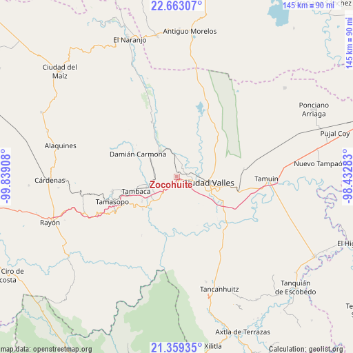
Zocohuite GPS coordinates[2]
22° 0' 45.756" North, 99° 8' 9.42" West
| Map corner | latitude | longitude |
|---|---|---|
| Upper-left | 22.66307°, | -99.83908° |
| Center: | 22.01271°, | -99.13595° |
| Lower-right: | 21.35935°, | -98.43283° |
| Map W x H: | 145×145 km | = 90.1×90.1mi |
| max Lat: | 32.7° ⇑15.7% North |
| Zocohuite: | 22.01271° |
| min Lat: | ⇓84.3% South 14.53588° |
| min Long | Zocohuite | max Long |
| -117.105° | -99.13595° | -86.73105° |
| W 48.4%⇐ | ⇒51.6% E |
Elevation
Elevation of Zocohuite is 159 m = 522 ft, and this is 1094.7 m = 3592 ft below average elevation for this country.
| Max E: |
3497 m = 11473 ft | 76.8% |
| Avg. | 1253.7 m = 4113 ft | |
| Zocohuite | 159 m = 522 ft | |
Min E: |
-1 m = -3 ft | 23.2% |
See also: Mexico elevation on elevation.city.
Geographical zone
Zocohuite is located in North Torrid zone (between Equator and Tropic of Cancer). Distance of this Northern Tropic circle is 158.3 km =98.4 mi to North.| Distance of | km | miles | from Zocohuite |
|---|---|---|---|
| North Pole | 7559.5 | 4697.3 | to North |
| Arctic Circle | 4953.6 | 3078 | to North |
| Tropic Cancer | 158.3 | 98.4 | to North |
| Equator | 2447.6 | 1520.9 | to South |


Nearby cities:
15 places around Zocohuite: (largest is in red/bold)
• Chino
13.5 km =8.4 mi,  276°
276°
• Ciudad Valles
13 km =8.1 mi,  98°
98°
• Coyoles
4 km =2.5 mi,  31°
31°
• Ejido la Hincada
12.8 km =8 mi,  324°
324°
• El Jabalí
16.9 km =10.5 mi,  217°
217°
• El Ojite
5.2 km =3.2 mi,  156°
156°
• Estacion San Dieguito
9 km =5.6 mi,  267°
267°
• La Lima
10.1 km =6.3 mi, 160°
• La Subida
12.6 km =7.8 mi, 162°
• Los Otates
3.7 km =2.3 mi,  228°
228°
• Nuevo Crucitas
12.8 km =8 mi,  326°
326°
• Ojo de Agua
6.1 km =3.8 mi, 158°
• Rancho Nuevo
16 km =9.9 mi, 162°
• Rascón
13.4 km =8.3 mi,  249°
249°
• San Antonio Huichimal
8.7 km =5.4 mi, 159°
Sources, notices
• [Note1] Compared only with cities in Mexico existing in our database
• [Src1] Map data: © OpenStreetMap contributors (CC-BY-SA)
• [Src2] Other city data from geonames.org with taken over terms of usage.
• [Src3] Geographical zone / Annual Mean Temperature by Robert A. Rohde @ Wikipedia
