San Antonio Huichimal geodata
San Antonio Huichimal (San Luis Potosí) is a populated place; located in Mexico in America/Mexico_City (GMT-6) time zone. With population of 839 people, there are 10431 cities with bigger population in this country. Compared to other cities in Mexico, 83.7% of cities are located further ↓South; 51.2% of cities are located further →East and 76.9% of cities have higher elevation than San Antonio Huichimal. Note1


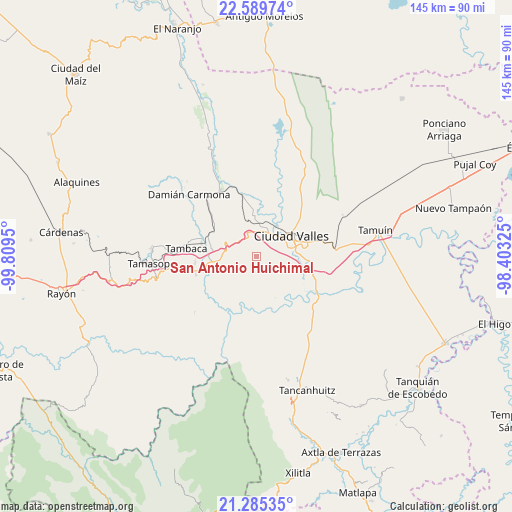
San Antonio Huichimal GPS coordinates[2]
21° 56' 20.544" North, 99° 6' 22.932" West
| Map corner | latitude | longitude |
|---|---|---|
| Upper-left | 22.58974°, | -99.8095° |
| Center: | 21.93904°, | -99.10637° |
| Lower-right: | 21.28535°, | -98.40325° |
| Map W x H: | 145×145 km | = 90.1×90.1mi |
| max Lat: | 32.7° ⇑16.3% North |
| San Antonio Huichimal: | 21.93904° |
| min Lat: | ⇓83.7% South 14.53588° |
| min Long | San Antonio Hui | max Long |
| -117.105° | -99.10637° | -86.73105° |
| W 48.8%⇐ | ⇒51.2% E |
Elevation
Elevation of San Antonio Huichimal is 155 m = 509 ft, and this is 1098.7 m = 3605 ft below average elevation for this country.
| Max E: |
3497 m = 11473 ft | 76.9% |
| Avg. | 1253.7 m = 4113 ft | |
| San Antonio Huichimal | 155 m = 509 ft | |
Min E: |
-1 m = -3 ft | 23.1% |
See also: Mexico elevation on elevation.city.
Geographical zone
San Antonio Huichimal is located in North Torrid zone (between Equator and Tropic of Cancer). Distance of this Northern Tropic circle is 166.5 km =103.5 mi to North.| Distance of | km | miles | from San Antonio Huichimal |
|---|---|---|---|
| North Pole | 7567.7 | 4702.3 | to North |
| Arctic Circle | 4961.8 | 3083.1 | to North |
| Tropic Cancer | 166.5 | 103.5 | to North |
| Equator | 2439.4 | 1515.8 | to South |


Nearby cities:
15 places around San Antonio Huichimal: (largest is in red/bold)
• Ciudad Valles
11.7 km =7.3 mi,  57°
57°
• Coyoles
11.6 km =7.2 mi,  355°
355°
• El Jabalí
14.4 km =8.9 mi,  248°
248°
• El Naranjito
12.3 km =7.6 mi,  216°
216°
• El Ojite
3.5 km =2.2 mi,  344°
344°
• Estacion San Dieguito
14.3 km =8.9 mi,  302°
302°
• La Lima
1.4 km =0.9 mi,  164°
164°
• La Pila
8.2 km =5.1 mi, 162°
• La Subida
3.9 km =2.4 mi,  168°
168°
• Los Otates
8.2 km =5.1 mi,  314°
314°
• Ojo de Agua
2.6 km =1.6 mi, 342°
• Rancho Nuevo
7.2 km =4.5 mi, 165°
• Rascón
16 km =9.9 mi,  282°
282°
• Tanchachín
12.8 km =8 mi,  199°
199°
• Zocohuite
8.7 km =5.4 mi, 339°
Sources, notices
• [Note1] Compared only with cities in Mexico existing in our database
• [Src1] Map data: © OpenStreetMap contributors (CC-BY-SA)
• [Src2] Other city data from geonames.org with taken over terms of usage.
• [Src3] Geographical zone / Annual Mean Temperature by Robert A. Rohde @ Wikipedia
