Teotzacualco geodata
Teotzacualco (Veracruz) is a populated place; located in Mexico in America/Mexico_City (GMT-6) time zone. With population of 567 people, there are 15067 cities with bigger population in this country. Compared to other cities in Mexico, 69.9% of cities are located further ↑North; 75% of cities are located further ←West and 56.7% of cities have higher elevation than Teotzacualco. Note1


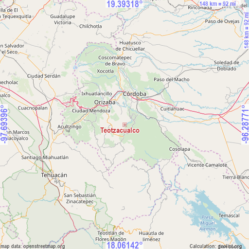
Teotzacualco GPS coordinates[2]
18° 43' 42.996" North, 96° 59' 26.988" West
| Map corner | latitude | longitude |
|---|---|---|
| Upper-left | 19.39318°, | -97.69396° |
| Center: | 18.72861°, | -96.99083° |
| Lower-right: | 18.06142°, | -96.28771° |
| Map W x H: | 148.1×148.1 km | = 92×92mi |
| max Lat: | 32.7° ⇑69.9% North |
| Teotzacualco: | 18.72861° |
| min Lat: | ⇓30.1% South 14.53588° |
| min Long | Teotzacualco | max Long |
| -117.105° | -96.99083° | -86.73105° |
| W 75%⇐ | ⇒25% E |
Elevation
Elevation of Teotzacualco is 1131 m = 3711 ft, and this is 122.7 m = 403 ft below average elevation for this country.
| Max E: |
3497 m = 11473 ft | 56.7% |
| Avg. | 1253.7 m = 4113 ft | |
| Teotzacualco | 1131 m = 3711 ft | |
Min E: |
-1 m = -3 ft | 43.3% |
See also: Mexico elevation on elevation.city.
Geographical zone
Teotzacualco is located in North Torrid zone (between Equator and Tropic of Cancer). Distance of this Northern Tropic circle is 523.5 km =325.3 mi to North.| Distance of | km | miles | from Teotzacualco |
|---|---|---|---|
| North Pole | 7924.6 | 4924.1 | to North |
| Arctic Circle | 5318.7 | 3304.9 | to North |
| Tropic Cancer | 523.5 | 325.3 | to North |
| Equator | 2082.4 | 1293.9 | to South |


Nearby cities:
15 places around Teotzacualco: (largest is in red/bold)
• Capultitla
6.4 km =4 mi,  300°
300°
• Choapa
3.1 km =1.9 mi,  74°
74°
• Coetzapotitla
7.1 km =4.4 mi,  61°
61°
• Cotlaixco
6.1 km =3.8 mi,  45°
45°
• El Campanario
4.4 km =2.7 mi,  19°
19°
• Emiliano Zapata
6 km =3.7 mi, 66°
• Magdalena
6.8 km =4.2 mi, 301°
• Oxtotitla
1.9 km =1.2 mi,  254°
254°
• Poxcautla
2.1 km =1.3 mi,  39°
39°
• Rincón de Maravillas
6.2 km =3.9 mi,  353°
353°
• San José Independencia
5.7 km =3.5 mi, 57°
• San Sebastián
5.4 km =3.4 mi,  92°
92°
• Tlecuaxco
3.3 km =2.1 mi,  356°
356°
• Tuxpanguillo
6.4 km =4 mi,  338°
338°
• Zongolica
6.9 km =4.3 mi,  185°
185°
Sources, notices
• [Note1] Compared only with cities in Mexico existing in our database
• [Src1] Map data: © OpenStreetMap contributors (CC-BY-SA)
• [Src2] Other city data from geonames.org with taken over terms of usage.
• [Src3] Geographical zone / Annual Mean Temperature by Robert A. Rohde @ Wikipedia
