Zapotitlán geodata
Zapotitlán (Veracruz) is a populated place; located in Mexico in America/Mexico_City (GMT-6) time zone. With population of 700 people, there are 12436 cities with bigger population in this country. Compared to other cities in Mexico, 53.5% of cities are located further ↓South; 73% of cities are located further ←West and 64.8% of cities have higher elevation than Zapotitlán. Note1


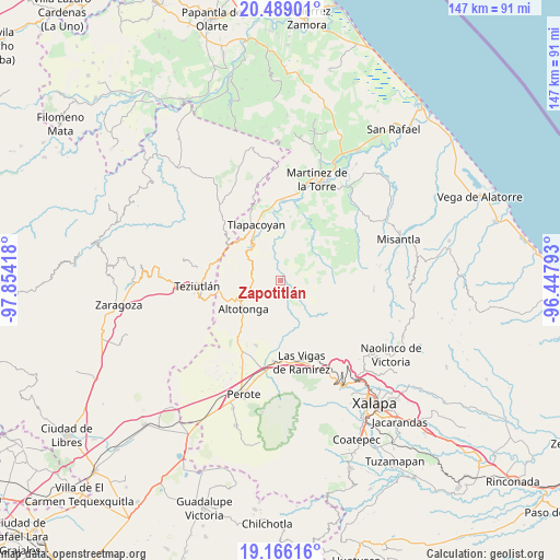
Zapotitlán GPS coordinates[2]
19° 49' 44.256" North, 97° 9' 3.78" West
| Map corner | latitude | longitude |
|---|---|---|
| Upper-left | 20.48901°, | -97.85418° |
| Center: | 19.82896°, | -97.15105° |
| Lower-right: | 19.16616°, | -96.44793° |
| Map W x H: | 147.1×147.1 km | = 91.4×91.4mi |
| max Lat: | 32.7° ⇑46.5% North |
| Zapotitlán: | 19.82896° |
| min Lat: | ⇓53.5% South 14.53588° |
| min Long | Zapotitlán | max Long |
| -117.105° | -97.15105° | -86.73105° |
| W 73%⇐ | ⇒27% E |
Elevation
Elevation of Zapotitlán is 695 m = 2280 ft, and this is 558.7 m = 1833 ft below average elevation for this country.
| Max E: |
3497 m = 11473 ft | 64.8% |
| Avg. | 1253.7 m = 4113 ft | |
| Zapotitlán | 695 m = 2280 ft | |
Min E: |
-1 m = -3 ft | 35.2% |
See also: Mexico elevation on elevation.city.
Geographical zone
Zapotitlán is located in North Torrid zone (between Equator and Tropic of Cancer). Distance of this Northern Tropic circle is 401.1 km =249.2 mi to North.| Distance of | km | miles | from Zapotitlán |
|---|---|---|---|
| North Pole | 7802.3 | 4848.1 | to North |
| Arctic Circle | 5196.4 | 3228.9 | to North |
| Tropic Cancer | 401.1 | 249.2 | to North |
| Equator | 2204.8 | 1370 | to South |


Nearby cities:
15 places around Zapotitlán: (largest is in red/bold)
• Ahuateno
8.6 km =5.3 mi,  9°
9°
• Atzalan
10.5 km =6.5 mi,  244°
244°
• Cuauzapotitán
8.7 km =5.4 mi,  336°
336°
• Ictzictic
7 km =4.3 mi,  229°
229°
• La Florida
10.3 km =6.4 mi,  251°
251°
• La Prensa
7.7 km =4.8 mi,  117°
117°
• Las Truchas
8.4 km =5.2 mi,  125°
125°
• Mecacalco
7.2 km =4.5 mi,  148°
148°
• Mexcalteco
3.6 km =2.2 mi,  102°
102°
• Plan de Arroyos
8.4 km =5.2 mi,  31°
31°
• Río Vasco
8.1 km =5 mi,  155°
155°
• Santiago
9.8 km =6.1 mi,  358°
358°
• Temimilco
6.5 km =4 mi, 115°
• Tiocuautla
9.8 km =6.1 mi, 150°
• Xoampolco
11.2 km =7 mi, 227°
Sources, notices
• [Note1] Compared only with cities in Mexico existing in our database
• [Src1] Map data: © OpenStreetMap contributors (CC-BY-SA)
• [Src2] Other city data from geonames.org with taken over terms of usage.
• [Src3] Geographical zone / Annual Mean Temperature by Robert A. Rohde @ Wikipedia
