Atzalan geodata
Atzalan (Veracruz) is a seat of a second-order administrative division; located in Mexico in America/Mexico_City (GMT-6) time zone. With population of 1,940 people, there are 4485 cities with bigger population in this country. Compared to other cities in Mexico, 52.5% of cities are located further ↓South; 72.1% of cities are located further ←West and 57.5% of cities have lower elevation than Atzalan. Note1


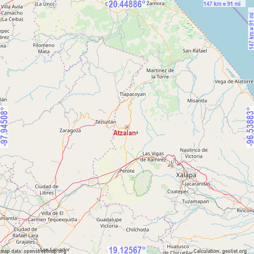
Atzalan GPS coordinates[2]
19° 47' 19.104" North, 97° 14' 31.02" West
| Map corner | latitude | longitude |
|---|---|---|
| Upper-left | 20.44886°, | -97.94508° |
| Center: | 19.78864°, | -97.24195° |
| Lower-right: | 19.12567°, | -96.53883° |
| Map W x H: | 147.1×147.1 km | = 91.4×91.4mi |
| max Lat: | 32.7° ⇑47.5% North |
| Atzalan: | 19.78864° |
| min Lat: | ⇓52.5% South 14.53588° |
| min Long | Atzalan | max Long |
| -117.105° | -97.24195° | -86.73105° |
| W 72.1%⇐ | ⇒27.9% E |
Elevation
Elevation of Atzalan is 1678 m = 5505 ft, and this is 424.3 m = 1392 ft above average elevation for this country.
| Max E: |
3497 m = 11473 ft | 42.5% |
| Atzalan | 1678 m 5505 ft | |
| Avg. | 1253.7 m = 4113 ft | |
Min E: |
-1 m = -3 ft | 57.5% |
See also: Mexico elevation on elevation.city.
Geographical zone
Atzalan is located in North Torrid zone (between Equator and Tropic of Cancer). Distance of this Northern Tropic circle is 405.6 km =252 mi to North.| Distance of | km | miles | from Atzalan |
|---|---|---|---|
| North Pole | 7806.8 | 4850.9 | to North |
| Arctic Circle | 5200.9 | 3231.7 | to North |
| Tropic Cancer | 405.6 | 252 | to North |
| Equator | 2200.3 | 1367.2 | to South |


Nearby cities:
15 places around Atzalan: (largest is in red/bold)
• Adolfo Moreno
7.1 km =4.4 mi,  176°
176°
• Ahuacatán
5.9 km =3.7 mi,  264°
264°
• Altotonga
2.5 km =1.6 mi,  187°
187°
• Buena Vista
4.5 km =2.8 mi,  157°
157°
• Champilico
5.6 km =3.5 mi,  199°
199°
• Ictzictic
4.2 km =2.6 mi,  90°
90°
• Jalacingo
7.1 km =4.4 mi,  283°
283°
• La Florida
1.3 km =0.8 mi,  348°
348°
• Loma de Hidalgo
7.3 km =4.5 mi,  230°
230°
• Miguel Hidalgo
5.4 km =3.4 mi, 230°
• Ocotepec
4 km =2.5 mi,  301°
301°
• San Miguel Tlalpoalán
5.7 km =3.5 mi, 163°
• Texacaxco
3.4 km =2.1 mi,  218°
218°
• Xoampolco
3.4 km =2.1 mi, 157°
• Zoatzingo
6.9 km =4.3 mi, 186°
Sources, notices
• [Note1] Compared only with cities in Mexico existing in our database
• [Src1] Map data: © OpenStreetMap contributors (CC-BY-SA)
• [Src2] Other city data from geonames.org with taken over terms of usage.
• [Src3] Geographical zone / Annual Mean Temperature by Robert A. Rohde @ Wikipedia
