La Prensa geodata
La Prensa (Veracruz) is a populated place; located in Mexico in America/Mexico_City (GMT-6) time zone. With population of 503 people, there are 16722 cities with bigger population in this country. Compared to other cities in Mexico, 52.7% of cities are located further ↓South; 73.8% of cities are located further ←West and 60.9% of cities have higher elevation than La Prensa. Note1


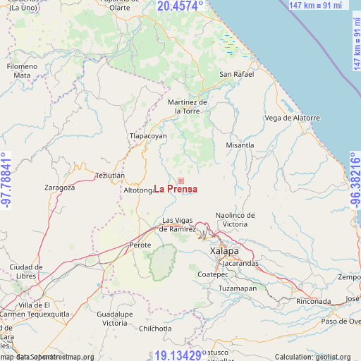
La Prensa GPS coordinates[2]
19° 47' 49.992" North, 97° 5' 7.008" West
| Map corner | latitude | longitude |
|---|---|---|
| Upper-left | 20.4574°, | -97.78841° |
| Center: | 19.79722°, | -97.08528° |
| Lower-right: | 19.13429°, | -96.38216° |
| Map W x H: | 147.1×147.1 km | = 91.4×91.4mi |
| max Lat: | 32.7° ⇑47.3% North |
| La Prensa: | 19.79722° |
| min Lat: | ⇓52.7% South 14.53588° |
| min Long | La Prensa | max Long |
| -117.105° | -97.08528° | -86.73105° |
| W 73.8%⇐ | ⇒26.2% E |
Elevation
Elevation of La Prensa is 946 m = 3104 ft, and this is 307.7 m = 1010 ft below average elevation for this country.
| Max E: |
3497 m = 11473 ft | 60.9% |
| Avg. | 1253.7 m = 4113 ft | |
| La Prensa | 946 m = 3104 ft | |
Min E: |
-1 m = -3 ft | 39.1% |
See also: Mexico elevation on elevation.city.
Geographical zone
La Prensa is located in North Torrid zone (between Equator and Tropic of Cancer). Distance of this Northern Tropic circle is 404.7 km =251.5 mi to North.| Distance of | km | miles | from La Prensa |
|---|---|---|---|
| North Pole | 7805.8 | 4850.3 | to North |
| Arctic Circle | 5199.9 | 3231.1 | to North |
| Tropic Cancer | 404.7 | 251.5 | to North |
| Equator | 2201.2 | 1367.8 | to South |


Nearby cities:
15 places around La Prensa: (largest is in red/bold)
• Ahuateno
13.2 km =8.2 mi,  335°
335°
• Ictzictic
12.2 km =7.6 mi,  265°
265°
• Juan Marcos (San José Buenavista)
13.9 km =8.6 mi,  237°
237°
• La Mancuerna
12.9 km =8 mi,  199°
199°
• Las Minas
13.4 km =8.3 mi,  208°
208°
• Las Truchas
1.3 km =0.8 mi,  182°
182°
• Mecacalco
4.1 km =2.5 mi,  229°
229°
• Mexcalteco
4.4 km =2.7 mi,  308°
308°
• Plan de Arroyos
10.9 km =6.8 mi,  346°
346°
• Quilate Nuevo
13.7 km =8.5 mi,  50°
50°
• Río Vasco
5.3 km =3.3 mi,  223°
223°
• Tatatila
11.9 km =7.4 mi,  193°
193°
• Temimilco
1.3 km =0.8 mi, 306°
• Tiocuautla
5.3 km =3.3 mi, 202°
• Zapotitlán
7.7 km =4.8 mi,  297°
297°
Sources, notices
• [Note1] Compared only with cities in Mexico existing in our database
• [Src1] Map data: © OpenStreetMap contributors (CC-BY-SA)
• [Src2] Other city data from geonames.org with taken over terms of usage.
• [Src3] Geographical zone / Annual Mean Temperature by Robert A. Rohde @ Wikipedia
