Zacualtipán geodata
Zacualtipán (Hidalgo) is a populated place; located in Mexico in America/Mexico_City (GMT-6) time zone. With population of 23,125 people, there are 442 cities with bigger population in this country. Compared to other cities in Mexico, 70.9% of cities are located further ↓South; 55.6% of cities are located further ←West and 73.1% of cities have lower elevation than Zacualtipán. Note1


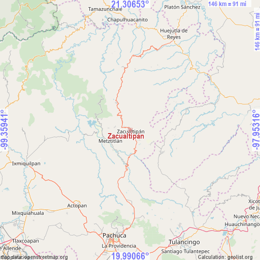
Zacualtipán GPS coordinates[2]
20° 39' 0.072" North, 98° 39' 22.608" West
| Map corner | latitude | longitude |
|---|---|---|
| Upper-left | 21.30653°, | -99.35941° |
| Center: | 20.65002°, | -98.65628° |
| Lower-right: | 19.99066°, | -97.95316° |
| Map W x H: | 146.3×146.3 km | = 90.9×90.9mi |
| max Lat: | 32.7° ⇑29.1% North |
| Zacualtipán: | 20.65002° |
| min Lat: | ⇓70.9% South 14.53588° |
| min Long | Zacualtipán | max Long |
| -117.105° | -98.65628° | -86.73105° |
| W 55.6%⇐ | ⇒44.4% E |
Elevation
Elevation of Zacualtipán is 1990 m = 6529 ft, and this is 736.3 m = 2416 ft above average elevation for this country.
| Max E: |
3497 m = 11473 ft | 26.9% |
| Zacualtipán | 1990 m 6529 ft | |
| Avg. | 1253.7 m = 4113 ft | |
Min E: |
-1 m = -3 ft | 73.1% |
See also: Mexico elevation on elevation.city.
Geographical zone
Zacualtipán is located in North Torrid zone (between Equator and Tropic of Cancer). Distance of this Northern Tropic circle is 309.9 km =192.6 mi to North.| Distance of | km | miles | from Zacualtipán |
|---|---|---|---|
| North Pole | 7711 | 4791.4 | to North |
| Arctic Circle | 5105.1 | 3172.2 | to North |
| Tropic Cancer | 309.9 | 192.6 | to North |
| Equator | 2296.1 | 1426.7 | to South |


Nearby cities:
15 places around Zacualtipán: (largest is in red/bold)
• Alumbres
4 km =2.5 mi,  301°
301°
• Atopixco
7.4 km =4.6 mi,  136°
136°
• Carpinteros
14.1 km =8.8 mi,  120°
120°
• Coatlila
8.3 km =5.2 mi,  60°
60°
• La Mojonera
4.6 km =2.9 mi,  126°
126°
• Malila
11.2 km =7 mi,  323°
323°
• Metztitlán
12.7 km =7.9 mi,  241°
241°
• Mezquititlán
13.1 km =8.1 mi,  171°
171°
• Nonoalco
8.7 km =5.4 mi,  327°
327°
• Santa Mónica
8.5 km =5.3 mi,  353°
353°
• Soyatla
6.7 km =4.2 mi,  40°
40°
• Tianguistengo
9 km =5.6 mi,  16°
16°
• Tizapán
6.1 km =3.8 mi,  88°
88°
• Tlahuelompa (San Francisco Tlahuelompa)
8.4 km =5.2 mi, 89°
• Tuzanapa
10.9 km =6.8 mi, 136°
Sources, notices
• [Note1] Compared only with cities in Mexico existing in our database
• [Src1] Map data: © OpenStreetMap contributors (CC-BY-SA)
• [Src2] Other city data from geonames.org with taken over terms of usage.
• [Src3] Geographical zone / Annual Mean Temperature by Robert A. Rohde @ Wikipedia
