La Mojonera geodata
La Mojonera (Hidalgo) is a populated place; located in Mexico in America/Mexico_City (GMT-6) time zone. With population of 839 people, there are 10431 cities with bigger population in this country. Compared to other cities in Mexico, 70.5% of cities are located further ↓South; 55.9% of cities are located further ←West and 75.9% of cities have lower elevation than La Mojonera. Note1


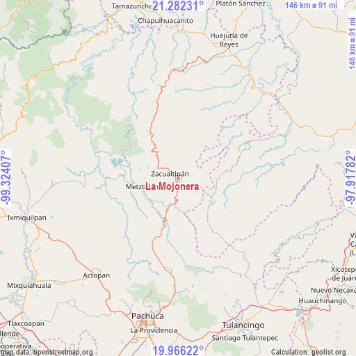
La Mojonera GPS coordinates[2]
20° 37' 32.484" North, 98° 37' 15.384" West
| Map corner | latitude | longitude |
|---|---|---|
| Upper-left | 21.28231°, | -99.32407° |
| Center: | 20.62569°, | -98.62094° |
| Lower-right: | 19.96622°, | -97.91782° |
| Map W x H: | 146.3×146.3 km | = 90.9×90.9mi |
| max Lat: | 32.7° ⇑29.5% North |
| La Mojonera: | 20.62569° |
| min Lat: | ⇓70.5% South 14.53588° |
| min Long | La Mojonera | max Long |
| -117.105° | -98.62094° | -86.73105° |
| W 55.9%⇐ | ⇒44.1% E |
Elevation
Elevation of La Mojonera is 2047 m = 6716 ft, and this is 793.3 m = 2603 ft above average elevation for this country.
| Max E: |
3497 m = 11473 ft | 24.1% |
| La Mojonera | 2047 m 6716 ft | |
| Avg. | 1253.7 m = 4113 ft | |
Min E: |
-1 m = -3 ft | 75.9% |
See also: Mexico elevation on elevation.city.
Geographical zone
La Mojonera is located in North Torrid zone (between Equator and Tropic of Cancer). Distance of this Northern Tropic circle is 312.6 km =194.2 mi to North.| Distance of | km | miles | from La Mojonera |
|---|---|---|---|
| North Pole | 7713.7 | 4793.1 | to North |
| Arctic Circle | 5107.8 | 3173.8 | to North |
| Tropic Cancer | 312.6 | 194.2 | to North |
| Equator | 2293.4 | 1425.1 | to South |


Nearby cities:
15 places around La Mojonera: (largest is in red/bold)
• Alumbres
8.6 km =5.3 mi,  304°
304°
• Atopixco
3.1 km =1.9 mi,  152°
152°
• Carpinteros
9.5 km =5.9 mi,  117°
117°
• Coatlila
7.7 km =4.8 mi,  27°
27°
• Jalapa
12.1 km =7.5 mi,  64°
64°
• Mezquititlán
10.4 km =6.5 mi,  189°
189°
• Nonoalco
13 km =8.1 mi,  320°
320°
• Santa Mónica
12.1 km =7.5 mi,  337°
337°
• Soyatla
7.8 km =4.8 mi,  4°
4°
• Tianguistengo
11.4 km =7.1 mi,  354°
354°
• Tizapán
3.8 km =2.4 mi,  40°
40°
• Tlahuelompa (San Francisco Tlahuelompa)
5.5 km =3.4 mi, 59°
• Tuzanapa
6.4 km =4 mi,  143°
143°
• Xoxoteco
12.3 km =7.6 mi,  182°
182°
• Zacualtipán
4.6 km =2.9 mi,  306°
306°
Sources, notices
• [Note1] Compared only with cities in Mexico existing in our database
• [Src1] Map data: © OpenStreetMap contributors (CC-BY-SA)
• [Src2] Other city data from geonames.org with taken over terms of usage.
• [Src3] Geographical zone / Annual Mean Temperature by Robert A. Rohde @ Wikipedia
