Atopixco geodata
Atopixco (Hidalgo) is a populated place; located in Mexico in America/Mexico_City (GMT-6) time zone. With population of 895 people, there are 9743 cities with bigger population in this country. Compared to other cities in Mexico, 70% of cities are located further ↓South; 56% of cities are located further ←West and 75.3% of cities have lower elevation than Atopixco. Note1


Atopixco GPS coordinates[2]
20° 36' 4.68" North, 98° 36' 26.208" West
| Map corner | latitude | longitude |
|---|---|---|
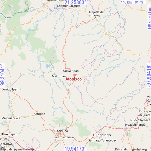
| Upper-left | 21.25803°, | -99.31041° |
| Center: | 20.6013°, | -98.60728° |
| Lower-right: | 19.94173°, | -97.90416° |
| Map W x H: | 146.4×146.4 km | = 91×91mi |
| max Lat: | 32.7° ⇑30% North |
| Atopixco: | 20.6013° |
| min Lat: | ⇓70% South 14.53588° |
| min Long | Atopixco | max Long |
| -117.105° | -98.60728° | -86.73105° |
| W 56%⇐ | ⇒44% E |
Elevation
Elevation of Atopixco is 2035 m = 6677 ft, and this is 781.3 m = 2563 ft above average elevation for this country.
| Max E: |
3497 m = 11473 ft | 24.7% |
| Atopixco | 2035 m 6677 ft | |
| Avg. | 1253.7 m = 4113 ft | |
Min E: |
-1 m = -3 ft | 75.3% |
See also: Mexico elevation on elevation.city.
Geographical zone
Atopixco is located in North Torrid zone (between Equator and Tropic of Cancer). Distance of this Northern Tropic circle is 315.3 km =195.9 mi to North.| Distance of | km | miles | from Atopixco |
|---|---|---|---|
| North Pole | 7716.4 | 4794.7 | to North |
| Arctic Circle | 5110.5 | 3175.5 | to North |
| Tropic Cancer | 315.3 | 195.9 | to North |
| Equator | 2290.6 | 1423.3 | to South |


Nearby cities:
15 places around Atopixco: (largest is in red/bold)
• Alumbres
11.4 km =7.1 mi,  311°
311°
• Atecoxco
10.6 km =6.6 mi,  169°
169°
• Carpinteros
7.2 km =4.5 mi,  103°
103°
• Coatlila
9.7 km =6 mi,  12°
12°
• Jalapa
12.4 km =7.7 mi,  49°
49°
• La Mojonera
3.1 km =1.9 mi,  332°
332°
• La Selva
11.3 km =7 mi,  109°
109°
• Mezquititlán
8.2 km =5.1 mi,  202°
202°
• Soyatla
10.5 km =6.5 mi,  355°
355°
• Tianguistengo
14.3 km =8.9 mi,  349°
349°
• Tizapán
5.7 km =3.5 mi, 10°
• Tlahuelompa (San Francisco Tlahuelompa)
6.4 km =4 mi,  31°
31°
• Tuzanapa
3.4 km =2.1 mi,  134°
134°
• Xoxoteco
9.8 km =6.1 mi,  190°
190°
• Zacualtipán
7.4 km =4.6 mi,  316°
316°
Sources, notices
• [Note1] Compared only with cities in Mexico existing in our database
• [Src1] Map data: © OpenStreetMap contributors (CC-BY-SA)
• [Src2] Other city data from geonames.org with taken over terms of usage.
• [Src3] Geographical zone / Annual Mean Temperature by Robert A. Rohde @ Wikipedia
