Coatlila geodata
Coatlila (Hidalgo) is a populated place; located in Mexico in America/Mexico_City (GMT-6) time zone. With population of 617 people, there are 13976 cities with bigger population in this country. Compared to other cities in Mexico, 71.4% of cities are located further ↓South; 56.2% of cities are located further ←West and 55.7% of cities have lower elevation than Coatlila. Note1


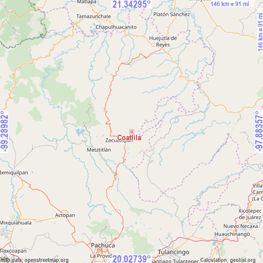
Coatlila GPS coordinates[2]
20° 41' 11.76" North, 98° 35' 12.084" West
| Map corner | latitude | longitude |
|---|---|---|
| Upper-left | 21.34295°, | -99.28982° |
| Center: | 20.6866°, | -98.58669° |
| Lower-right: | 20.02739°, | -97.88357° |
| Map W x H: | 146.3×146.3 km | = 90.9×90.9mi |
| max Lat: | 32.7° ⇑28.6% North |
| Coatlila: | 20.6866° |
| min Lat: | ⇓71.4% South 14.53588° |
| min Long | Coatlila | max Long |
| -117.105° | -98.58669° | -86.73105° |
| W 56.2%⇐ | ⇒43.8% E |
Elevation
Elevation of Coatlila is 1609 m = 5279 ft, and this is 355.3 m = 1166 ft above average elevation for this country.
| Max E: |
3497 m = 11473 ft | 44.3% |
| Coatlila | 1609 m 5279 ft | |
| Avg. | 1253.7 m = 4113 ft | |
Min E: |
-1 m = -3 ft | 55.7% |
See also: Mexico elevation on elevation.city.
Geographical zone
Coatlila is located in North Torrid zone (between Equator and Tropic of Cancer). Distance of this Northern Tropic circle is 305.8 km =190 mi to North.| Distance of | km | miles | from Coatlila |
|---|---|---|---|
| North Pole | 7706.9 | 4788.8 | to North |
| Arctic Circle | 5101 | 3169.6 | to North |
| Tropic Cancer | 305.8 | 190 | to North |
| Equator | 2300.1 | 1429.2 | to South |


Nearby cities:
15 places around Coatlila: (largest is in red/bold)
• Alumbres
10.8 km =6.7 mi,  259°
259°
• Apachitla
12 km =7.5 mi,  68°
68°
• Atopixco
9.7 km =6 mi,  192°
192°
• Ixcotitlán
9.7 km =6 mi,  36°
36°
• Jalapa
7.5 km =4.7 mi,  101°
101°
• La Mojonera
7.7 km =4.8 mi,  207°
207°
• Polintotla
12 km =7.5 mi, 43°
• San Pablo Mitecatlán
7.1 km =4.4 mi, 71°
• Santa Mónica
9.2 km =5.7 mi,  298°
298°
• Soyatla
3 km =1.9 mi,  288°
288°
• Tianguistengo
6.6 km =4.1 mi,  314°
314°
• Tizapán
4.1 km =2.5 mi,  196°
196°
• Tlahuelompa (San Francisco Tlahuelompa)
4.2 km =2.6 mi,  163°
163°
• Tuzanapa
11.9 km =7.4 mi,  178°
178°
• Zacualtipán
8.3 km =5.2 mi,  240°
240°
Sources, notices
• [Note1] Compared only with cities in Mexico existing in our database
• [Src1] Map data: © OpenStreetMap contributors (CC-BY-SA)
• [Src2] Other city data from geonames.org with taken over terms of usage.
• [Src3] Geographical zone / Annual Mean Temperature by Robert A. Rohde @ Wikipedia
