Santiago Yogana geodata
Santiago Yogana (Oaxaca) is a seat of a second-order administrative division; located in Mexico in America/Mexico_City (GMT-6) time zone. With population of 1,284 people, there are 6748 cities with bigger population in this country. Compared to other cities in Mexico, 94.6% of cities are located further ↑North; 77.4% of cities are located further ←West and 51.5% of cities have higher elevation than Santiago Yogana. Note1


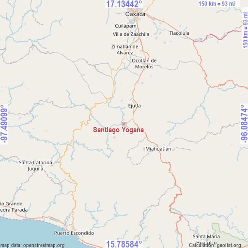
Santiago Yogana GPS coordinates[2]
16° 27' 40.68" North, 96° 47' 16.296" West
| Map corner | latitude | longitude |
|---|---|---|
| Upper-left | 17.13442°, | -97.49099° |
| Center: | 16.4613°, | -96.78786° |
| Lower-right: | 15.78584°, | -96.08474° |
| Map W x H: | 149.9×150 km | = 93.1×93.2mi |
| max Lat: | 32.7° ⇑94.6% North |
| Santiago Yogana: | 16.4613° |
| min Lat: | ⇓5.4% South 14.53588° |
| min Long | Santiago Yogana | max Long |
| -117.105° | -96.78786° | -86.73105° |
| W 77.4%⇐ | ⇒22.6% E |
Elevation
Elevation of Santiago Yogana is 1361 m = 4465 ft, and this is 107.3 m = 352 ft above average elevation for this country.
| Max E: |
3497 m = 11473 ft | 51.5% |
| Santiago Yogana | 1361 m 4465 ft | |
| Avg. | 1253.7 m = 4113 ft | |
Min E: |
-1 m = -3 ft | 48.5% |
See also: Mexico elevation on elevation.city.
Geographical zone
Santiago Yogana is located in North Torrid zone (between Equator and Tropic of Cancer). Distance of this Northern Tropic circle is 775.6 km =481.9 mi to North.| Distance of | km | miles | from Santiago Yogana |
|---|---|---|---|
| North Pole | 8176.7 | 5080.8 | to North |
| Arctic Circle | 5570.8 | 3461.5 | to North |
| Tropic Cancer | 775.6 | 481.9 | to North |
| Equator | 1830.3 | 1137.3 | to South |


Nearby cities:
15 places around Santiago Yogana: (largest is in red/bold)
• Agua del Espino
14.5 km =9 mi,  354°
354°
• Agua del Sol
6.1 km =3.8 mi,  79°
79°
• Barranca Larga
6.9 km =4.3 mi,  58°
58°
• Ejutla de Crespo
13.1 km =8.1 mi,  27°
27°
• El Cerro de las Huertas
14.9 km =9.3 mi,  38°
38°
• El Zompantle
12.8 km =8 mi,  99°
99°
• Guixé
9.1 km =5.7 mi, 83°
• Hacienda Vieja
9.3 km =5.8 mi,  19°
19°
• La Compañía
11.3 km =7 mi,  342°
342°
• San Agustín Amatengo
5.5 km =3.4 mi,  358°
358°
• San Miguel Ejutla
14.2 km =8.8 mi, 21°
• San Nicolás
6.8 km =4.2 mi,  132°
132°
• San Simón Almolongas
9.5 km =5.9 mi, 129°
• San Vicente Coatlán
10.1 km =6.3 mi,  216°
216°
• Taniche
12.4 km =7.7 mi, 16°
Sources, notices
• [Note1] Compared only with cities in Mexico existing in our database
• [Src1] Map data: © OpenStreetMap contributors (CC-BY-SA)
• [Src2] Other city data from geonames.org with taken over terms of usage.
• [Src3] Geographical zone / Annual Mean Temperature by Robert A. Rohde @ Wikipedia
