San Simón Almolongas geodata
San Simón Almolongas (Oaxaca) is a seat of a second-order administrative division; located in Mexico in America/Mexico_City (GMT-6) time zone. With population of 1,269 people, there are 6826 cities with bigger population in this country. Compared to other cities in Mexico, 94.9% of cities are located further ↑North; 78.2% of cities are located further ←West and 51.9% of cities have lower elevation than San Simón Almolongas. Note1


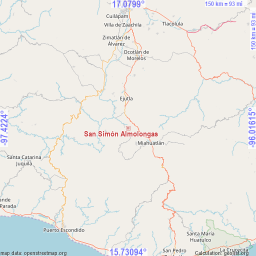
San Simón Almolongas GPS coordinates[2]
16° 24' 23.724" North, 96° 43' 9.372" West
| Map corner | latitude | longitude |
|---|---|---|
| Upper-left | 17.0799°, | -97.4224° |
| Center: | 16.40659°, | -96.71927° |
| Lower-right: | 15.73094°, | -96.01615° |
| Map W x H: | 150×150 km | = 93.2×93.2mi |
| max Lat: | 32.7° ⇑94.9% North |
| San Simón Almolongas: | 16.40659° |
| min Lat: | ⇓5.1% South 14.53588° |
| min Long | San Simón Almo | max Long |
| -117.105° | -96.71927° | -86.73105° |
| W 78.2%⇐ | ⇒21.8% E |
Elevation
Elevation of San Simón Almolongas is 1521 m = 4990 ft, and this is 267.3 m = 877 ft above average elevation for this country.
| Max E: |
3497 m = 11473 ft | 48.1% |
| San Simón Almolongas | 1521 m 4990 ft | |
| Avg. | 1253.7 m = 4113 ft | |
Min E: |
-1 m = -3 ft | 51.9% |
See also: Mexico elevation on elevation.city.
Geographical zone
San Simón Almolongas is located in North Torrid zone (between Equator and Tropic of Cancer). Distance of this Northern Tropic circle is 781.7 km =485.7 mi to North.| Distance of | km | miles | from San Simón Almolongas |
|---|---|---|---|
| North Pole | 8182.8 | 5084.6 | to North |
| Arctic Circle | 5576.9 | 3465.3 | to North |
| Tropic Cancer | 781.7 | 485.7 | to North |
| Equator | 1824.2 | 1133.5 | to South |


Nearby cities:
15 places around San Simón Almolongas: (largest is in red/bold)
• Agua del Sol
7.3 km =4.5 mi,  349°
349°
• Barranca Larga
9.8 km =6.1 mi, 351°
• El Zompantle
6.7 km =4.2 mi,  52°
52°
• Guixé
7.3 km =4.5 mi,  14°
14°
• La Soledad
10.5 km =6.5 mi,  79°
79°
• Monjas
9.2 km =5.7 mi,  116°
116°
• San Agustín Amatengo
13.8 km =8.6 mi,  327°
327°
• San Nicolás
2.8 km =1.7 mi,  302°
302°
• San Vicente Coatlán
13.4 km =8.3 mi,  261°
261°
• Santa Ana
7.3 km =4.5 mi,  178°
178°
• Santa Catarina Coatlán
13.3 km =8.3 mi,  206°
206°
• Santa Catarina Cuixtla
13.9 km =8.6 mi,  143°
143°
• Santa Cruz Xitla
10.5 km =6.5 mi,  152°
152°
• Santa María Velato
13.4 km =8.3 mi,  36°
36°
• Santiago Yogana
9.5 km =5.9 mi,  309°
309°
Sources, notices
• [Note1] Compared only with cities in Mexico existing in our database
• [Src1] Map data: © OpenStreetMap contributors (CC-BY-SA)
• [Src2] Other city data from geonames.org with taken over terms of usage.
• [Src3] Geographical zone / Annual Mean Temperature by Robert A. Rohde @ Wikipedia
