El Zompantle geodata
El Zompantle (Oaxaca) is a populated place; located in Mexico in America/Mexico_City (GMT-6) time zone. With population of 585 people, there are 14661 cities with bigger population in this country. Compared to other cities in Mexico, 94.7% of cities are located further ↑North; 78.7% of cities are located further ←West and 56.1% of cities have lower elevation than El Zompantle. Note1


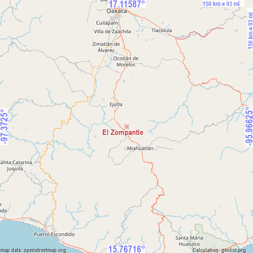
El Zompantle GPS coordinates[2]
16° 26' 33.684" North, 96° 40' 9.732" West
| Map corner | latitude | longitude |
|---|---|---|
| Upper-left | 17.11587°, | -97.3725° |
| Center: | 16.44269°, | -96.66937° |
| Lower-right: | 15.76716°, | -95.96625° |
| Map W x H: | 150×150 km | = 93.2×93.2mi |
| max Lat: | 32.7° ⇑94.7% North |
| El Zompantle: | 16.44269° |
| min Lat: | ⇓5.3% South 14.53588° |
| min Long | El Zompantle | max Long |
| -117.105° | -96.66937° | -86.73105° |
| W 78.7%⇐ | ⇒21.3% E |
Elevation
Elevation of El Zompantle is 1622 m = 5322 ft, and this is 368.3 m = 1208 ft above average elevation for this country.
| Max E: |
3497 m = 11473 ft | 43.9% |
| El Zompantle | 1622 m 5322 ft | |
| Avg. | 1253.7 m = 4113 ft | |
Min E: |
-1 m = -3 ft | 56.1% |
See also: Mexico elevation on elevation.city.
Geographical zone
El Zompantle is located in North Torrid zone (between Equator and Tropic of Cancer). Distance of this Northern Tropic circle is 777.7 km =483.2 mi to North.| Distance of | km | miles | from El Zompantle |
|---|---|---|---|
| North Pole | 8178.8 | 5082.1 | to North |
| Arctic Circle | 5572.9 | 3462.8 | to North |
| Tropic Cancer | 777.7 | 483.2 | to North |
| Equator | 1828.3 | 1136.1 | to South |


Nearby cities:
15 places around El Zompantle: (largest is in red/bold)
• Agua del Sol
7.3 km =4.5 mi,  295°
295°
• Barranca Larga
8.8 km =5.5 mi,  310°
310°
• Coatecas Altas
10.7 km =6.6 mi,  0°
0°
• El Cerro de las Huertas
14.1 km =8.8 mi,  346°
346°
• Guixé
4.7 km =2.9 mi, 310°
• Hacienda Vieja
14.4 km =8.9 mi,  318°
318°
• La Escalera
7.4 km =4.6 mi,  66°
66°
• La Soledad
5.5 km =3.4 mi,  113°
113°
• Monjas
8.6 km =5.3 mi,  160°
160°
• San Nicolás
8.1 km =5 mi,  251°
251°
• San Simón Almolongas
6.7 km =4.2 mi,  232°
232°
• Santa Ana
12.4 km =7.7 mi,  204°
204°
• Santa Cruz Xitla
13.3 km =8.3 mi,  181°
181°
• Santa María Velato
7.3 km =4.5 mi,  20°
20°
• Santiago Yogana
12.8 km =8 mi,  279°
279°
Sources, notices
• [Note1] Compared only with cities in Mexico existing in our database
• [Src1] Map data: © OpenStreetMap contributors (CC-BY-SA)
• [Src2] Other city data from geonames.org with taken over terms of usage.
• [Src3] Geographical zone / Annual Mean Temperature by Robert A. Rohde @ Wikipedia
