Yecuatla geodata
Yecuatla (Veracruz) is a seat of a second-order administrative division; located in Mexico in America/Mexico_City (GMT-6) time zone. With population of 3,048 people, there are 2955 cities with bigger population in this country. Compared to other cities in Mexico, 54.3% of cities are located further ↓South; 77.5% of cities are located further ←West and 69% of cities have higher elevation than Yecuatla. Note1


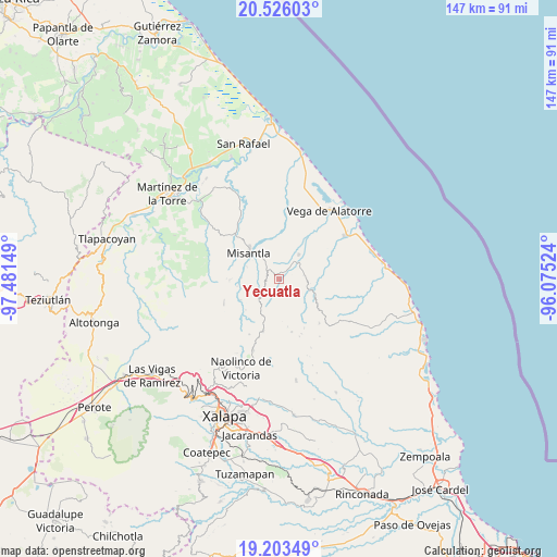
Yecuatla GPS coordinates[2]
19° 51' 58.104" North, 96° 46' 42.096" West
| Map corner | latitude | longitude |
|---|---|---|
| Upper-left | 20.52603°, | -97.48149° |
| Center: | 19.86614°, | -96.77836° |
| Lower-right: | 19.20349°, | -96.07524° |
| Map W x H: | 147.1×147.1 km | = 91.4×91.4mi |
| max Lat: | 32.7° ⇑45.7% North |
| Yecuatla: | 19.86614° |
| min Lat: | ⇓54.3% South 14.53588° |
| min Long | Yecuatla | max Long |
| -117.105° | -96.77836° | -86.73105° |
| W 77.5%⇐ | ⇒22.5% E |
Elevation
Elevation of Yecuatla is 468 m = 1535 ft, and this is 785.7 m = 2578 ft below average elevation for this country.
| Max E: |
3497 m = 11473 ft | 69% |
| Avg. | 1253.7 m = 4113 ft | |
| Yecuatla | 468 m = 1535 ft | |
Min E: |
-1 m = -3 ft | 31% |
See also: Mexico elevation on elevation.city.
Geographical zone
Yecuatla is located in North Torrid zone (between Equator and Tropic of Cancer). Distance of this Northern Tropic circle is 397 km =246.7 mi to North.| Distance of | km | miles | from Yecuatla |
|---|---|---|---|
| North Pole | 7798.2 | 4845.6 | to North |
| Arctic Circle | 5192.3 | 3226.3 | to North |
| Tropic Cancer | 397 | 246.7 | to North |
| Equator | 2208.9 | 1372.5 | to South |


Nearby cities:
15 places around Yecuatla: (largest is in red/bold)
• Arroyo Frío
11 km =6.8 mi,  7°
7°
• Colipa
8.3 km =5.2 mi,  40°
40°
• Cristóbal Hidalgo
2.8 km =1.7 mi,  129°
129°
• Cuautitlán del Parral
5.5 km =3.4 mi,  116°
116°
• Dos Arroyos
7.4 km =4.6 mi,  89°
89°
• Juchique de Ferrer
9.2 km =5.7 mi,  108°
108°
• La Reforma (Kilómetro 9)
4 km =2.5 mi,  305°
305°
• Las Paredes
10.3 km =6.4 mi,  217°
217°
• Leona Vicario
2.7 km =1.7 mi,  240°
240°
• Manuel Gutiérrez Nájera
11.9 km =7.4 mi,  226°
226°
• Misantla
10.5 km =6.5 mi, 312°
• Paso Blanco
9.9 km =6.2 mi,  271°
271°
• Plan de la Vega
10.2 km =6.3 mi,  347°
347°
• Pueblo Viejo
11.4 km =7.1 mi, 240°
• Venustiano Carranza
5.4 km =3.4 mi,  322°
322°
Sources, notices
• [Note1] Compared only with cities in Mexico existing in our database
• [Src1] Map data: © OpenStreetMap contributors (CC-BY-SA)
• [Src2] Other city data from geonames.org with taken over terms of usage.
• [Src3] Geographical zone / Annual Mean Temperature by Robert A. Rohde @ Wikipedia
